


4-3190-01102-02 Rev. B
Garmin G500 Pilot’s Guide
Foreword
Sec 1
System
Sec 2
PFD
Sec 3
MFD
Sec 4
Hazard
Avoidance
Sec 5
Additional
Features
Sec 6
Annun.
& Alerts
Sec 7
Symbols
Sec 8
Glossary Appendix A
Appendix B
Index
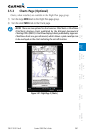
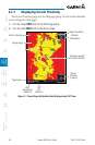
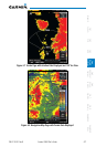
4.2 Terrain Proximity
Garmin TERRAIN is a non-TSO-C151b-certified terrain awareness system
provided as a standard feature of GDU 620 to increase situational awareness and
help reduce controlled flight into terrain (CFIT). Terrain may be displayed on
the Map page group Navigation Map and Terrain pages.
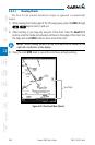
TERRAIN Proximity uses information provided from the GPS receiver to
provide a horizontal position and altitude. GPS altitude is derived from satellite
measurements. GPS altitude is converted to a Mean Sea Level (MSL)-based
altitude (GPS-MSL altitude) and is used to determine TERRAIN alerts. GPS-MSL
altitude accuracy is affected by factors such as satellite geometry, but it is not
subject to variations in pressure and temperature that normally affect pressure
altitude devices. GPS-MSL altitude does not require local altimeter settings to
determine MSL altitude. Therefore, GPS altitude provides a highly accurate and
reliable MSL altitude source to calculate terrain and obstacle alerts.
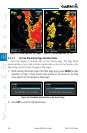
TERRAIN Proximity utilizes terrain and obstacle databases that are referenced
to mean sea level (MSL). Using the GPS position and GPS-MSL altitude, TERRAIN
Proximity displays a 2-D picture of the surrounding terrain and obstacles relative
to the position and altitude of the aircraft. In this manner, TERRAIN Proximity
can provide advanced alerts of predicted dangerous terrain conditions.
TERRAIN requires the following to operate properly:
•Thesystemmusthaveavalid3-DGPSpositionsolution.
•Thesystemmusthaveavalidterrain/obstacle/airportterraindatabase.