


4-83190-01102-02 Rev. B
Garmin G500 Pilot’s Guide
Foreword
Sec 1
System
Sec 2
PFD
Sec 3
MFD
Sec 4
Hazard
Avoidance
Sec 5
Additional
Features
Sec 6
Annun.
& Alerts
Sec 7
Symbols
Sec 8
Glossary Appendix A
Appendix B
Index
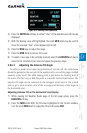
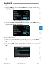
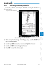
1) While viewing the Weather Radar page of the Wx page group, press the MENU
key.
2) To activate or deactivate Weather Alerts, turn the large or small
MFD knob to
highlight either “Enable Weather Alert” or “Inhibit Weather Alert.” Activating
and deactivating will also enable or inhibit the alert on the MFD.
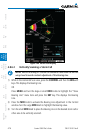
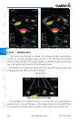
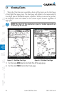
4.8.7 Ground Mapping and Interpretation
A secondary use of the weather radar system is for the presentation of terrain.
This can be a useful tool for verifying aircraft position. A “picture” of the ground
is represented much like a topographical map that can be used as a supplement
to the navigation map on the MFD.
Ground Map mode uses a different gain range than Weather mode. Different
colors are also used to represent the intensity levels. The displayed intensity of
ground target returns are defined in the following table. Use of the GAIN and
TILT controls will help improve contrast so that specific ground targets can be
recognized more easily. As previously discussed, the type and orientation of the
target in relation to the aircraft affects the intensity displayed.
When the weather radar system is in the either the Weather or Ground Map
mode, the system automatically switches to Standby mode.
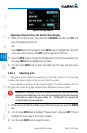
Ground Map
Mode Color
Intensity
BLACK 0 dB
LIGHT BLUE > 0 dB to < 9 dB
YELLOW 9 dB to < 18 dB
MAGENTA 18 dB to < 27 dB
BLUE 27 dB and greater
Table 4-18 Ground Target Return Intensity Levels