


4-24
Garmin G500 Pilot’s Guide
190-01102-02 Rev. B
Foreword
Sec 1
System
Sec 2
PFD
Sec 3
MFD
Sec 4
Hazard
Avoidance
Sec 5
Additional
Features
Sec 6
Annun.
& Alerts
Sec 7
Symbols
Sec 8
GlossaryAppendix A
Appendix B
Index
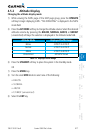
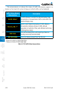
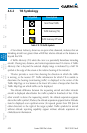
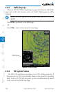
4.6.2 TIS Symbology
TIS Symbol Description
Non-Threat Traffic
Traffic Advisory (TA)
Traffic Advisory Off Scale
Table 4-10 TIS Traffic Symbols
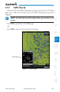
A Non-threat Advisory, shown as an open white diamond, indicates that an
intruding aircraft is at greater than ±1200 feet relative altitude or the distance is
beyond five NM.
A Traffic Advisory (TA) alerts the crew to a potentially hazardous intruding
aircraft. Closing rate, distance, and vertical separation meet TA criteria. A Traffic
Advisory that is beyond the selected display range is indicated by a half TA
symbol at the edge of the screen at the relative bearing of the intruder.
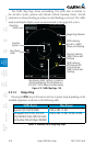
TIS also provides a vector line showing the direction in which the traffic
is moving, to the nearest 45º. Traffic information for which TIS is unable to
determine the bearing (non-bearing traffic) is displayed in the center of the
Traffic Map Page or in a banner at the lower left corner of maps other than the
Traffic Map Page on which traffic can be displayed.
The altitude difference between the requesting aircraft and other intruder
aircraft is displayed above/below the traffic symbol in hundreds of feet. If the
other aircraft is above the requesting aircraft, the altitude separation appears
above the traffic symbol; if below, the altitude separation appears below. Altitude
trend is displayed as an up/down arrow (for speeds greater than 500 fpm in
either direction) to the right of the target symbol. Traffic symbols for aircraft
without altitude reporting capability appear without altitude separation or
climb/descent information.