


5-14
Garmin G500 Pilot’s Guide
190-01102-02 Rev. B
Foreword
Sec 1
System
Sec 2
PFD
Sec 3
MFD
Sec 4
Hazard
Avoidance
Sec 5
Additional
Features
Sec 6
Annun.
& Alerts
Sec 7
Symbols
Sec 8
GlossaryAppendix A
Appendix B
Index
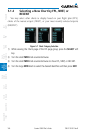
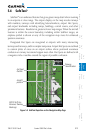
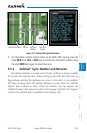
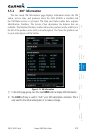
5.4.1 Using SafeTaxi
®
Any map page that displays the navigation view can also show the SafeTaxi
®
airport layout within the maximum configured range. The following is a list of
pages where the SafeTaxi feature can be seen:
•NavigationMapPage
•WeatherDatalinkPage
•AirportInformationPage
•IntersectionInformationPage
•NDB Information Page
•VOR Information Page
•UserWaypointInformation Page
During ground operations the aircraft’s position is displayed in reference to
taxiways, runways, and airport features. When panning over the airport, features
such as runway holding lines and taxiways are shown.
5.4.1.1 Decluttering
The DCLTR soft key (declutter) label advances to DCLTR-1, DCLTR -2, and
DCLTR-3 each time the soft key is selected for easy recognition of decluttering
level. Selecting the DCLTR soft key removes the taxiway markings and airport
feature labels. Selecting the DCLTR-1 soft key removes VOR station ID, the VOR
symbol, and intersection names if within the airport plan view. Selecting the
DCLTR-2 soft key removes the airport runway layout, unless the airport in view
is part of an active route structure. Pressing the DCLTR-3 soft key cycles back
to the original map detail. With Auto-Zoom enabled, the map will automatically
zoom to 1 NM and DCLTR-0 upon landing so SafeTaxi can be viewed. Refer to
Map Declutter Levels in the Navigation Map Section.
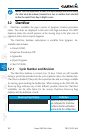
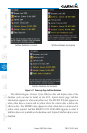
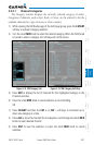
5.4.1.2 Hot Spot Information
Hot Spots can contain more information about the area that can be displayed
when selected.
1. While viewing the Hot Spot area on the Navigation Map page, press the small
MFD knob to activate the cursor.
2. Turn the MFD knobs to move the cursor on the Hot Spot border or into the Hot
Spot area and then press the ENT key.