


4-16
Garmin G500 Pilot’s Guide
190-01102-02 Rev. B
Foreword
Sec 1
System
Sec 2
PFD
Sec 3
MFD
Sec 4
Hazard
Avoidance
Sec 5
Additional
Features
Sec 6
Annun.
& Alerts
Sec 7
Symbols
Sec 8
GlossaryAppendix A
Appendix B
Index
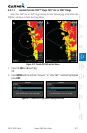
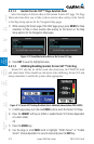
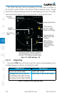
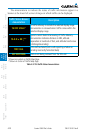
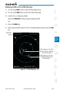
The Traffic Map Page shows surrounding TAS traffic data in relation to
the aircraft’s current position and altitude without basemap clutter. Aircraft
orientation is always heading up unless no valid heading is received. The traffic
mode and altitude display mode are annunciated in the upper left corner.
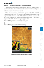
Traffic Advisory,
Off Scale Aircraft
is Out of Range,
1200 ft Above and
Climbing
Operating
Mode
Traffic Advisory,
Aircraft is 1200 ft
Above and Climbing
Range Ring Diameter
Non-Threat
Traffic
Proximity Advisory,
1200 ft Above and
Climbing
Non-Bearing Traffic (System is Unable to
Determine Bearing), Aircraft Distance is
8.0 NM, 1100 ft Above and Descending
Ownship
Symbol
Figure 4-15 Traffic Map Page - TAS
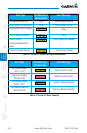
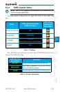
4.5.1.2 Range Ring
Pressing the RNG keys will zoom in and out in preset steps depending on the
installed equipment as shown in the following table.
Traffic Device Map Ranges
Skywatch (SKY497/SKY889) 2 NM, 6 NM, 12 NM
Honeywell KTA 810 TAS, KTA 910
TAS, KMH 820 IHAS, KMH 920 IHAS,
and Avidyne TAS 620 (Ryan 9900BX)
2 NM, 6 NM, 12 NM, 24 NM, 40 NM
Table 4-4 Available Traffic Range Ring Steps