


4-26
Garmin G500 Pilot’s Guide
190-01102-02 Rev. B
Foreword
Sec 1
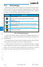
System
Sec 2
PFD
Sec 3
MFD
Sec 4
Hazard
Avoidance
Sec 5
Additional
Features
Sec 6
Annun.
& Alerts
Sec 7
Symbols
Sec 8
GlossaryAppendix A
Appendix B
Index
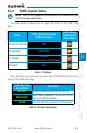
Garmin is not responsible for Mode S
geographical coverage. Operation of the
ground stations is the responsibility of the
FAA. Refer to the Aeronautical Information
Manual for a Terminal Mode S Radar Site Map
covering the U.S.
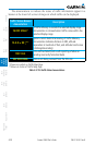
NOTE: TIS will be unavailable at low altitudes in many areas of the U.S.,
particularly in mountainous regions. Also, when flying near the “floor” of
radar coverage in a particular area, intruders below the client aircraft may
not be detected by TIS.
TIS information is collected one radar scan prior to the scan during which
the uplink occurs. Therefore, the surveillance information is approximately
five seconds old. In order to present the intruders in a “real time” position,
the TIS ground station uses a “predictive algorithm” in its tracking software.
This algorithm uses track history data to extrapolate intruders to their expected
positions consistent with the time of display in the cockpit. Occasionally, aircraft
maneuvering will cause this algorithm to induce errors in the display. These
errors primarily affect relative bearing information and traffic target track vector
(it will lag); intruder distance and altitude will remain relatively accurate and
may be used to assist in “see and avoid.” Some of the more common examples
of these errors follow:
•When client or intruder aircraft maneuvers excessively or abruptly, the
tracking algorithm may report incorrect horizontal position until the
maneuvering aircraft stabilizes.
•Whenarapidlyclosingintruderisonacoursethatcrossestheclientaircraft
course at a shallow angle (either overtaking or head on) and either aircraft
abruptly changes course within 0.25 NM, TIS may display the intruder on
the opposite side of the client than it actually is.
These are relatively rare occurrences and will be corrected in a few
radar scans once the course has stabilized.