


4-56
Garmin G500 Pilot’s Guide
190-01102-02 Rev. B
Foreword
Sec 1
System
Sec 2
PFD
Sec 3
MFD
Sec 4
Hazard
Avoidance
Sec 5
Additional
Features
Sec 6
Annun.
& Alerts
Sec 7
Symbols
Sec 8
GlossaryAppendix A
Appendix B
Index
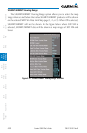
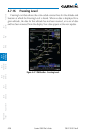
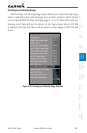
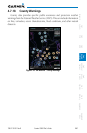
4.7.16 Freezing Level
Freezing Level data shows the color-coded contour lines for the altitude and
location at which the Freezing Level is found. When no data is displayed for a
given altitude, the data for that altitude has not been received, or is out of date
and has been removed from the display. New data appears at the next update.
Figure 4-47 XM Weather - Freezing Levels