


4-39190-01102-02 Rev. B
Garmin G500 Pilot’s Guide
Foreword
Sec 1
System
Sec 2
PFD
Sec 3
MFD
Sec 4
Hazard
Avoidance
Sec 5
Additional
Features
Sec 6
Annun.
& Alerts
Sec 7
Symbols
Sec 8
Glossary Appendix A
Appendix B
Index
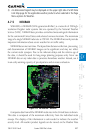
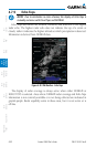
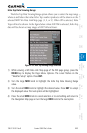
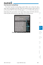
4.7.5.2 NEXRAD Limitations
NEXRAD radar images may have certain limitations:
•NEXRAD base reectivity does not provide sufficient information to
determine cloud layers or precipitation characteristics. For example, it is
not possible to distinguish between wet snow, wet hail, and rain.
•NEXRADbasereectivityissampledattheminimumantennaelevation
angle. An individual NEXRAD site cannot depict high altitude storms at
close ranges. It has no information about storms directly over the site.
•Whenzoomedintoarangeof30NM,eachsquareblockonthedisplay
represents an area of four square kilometers. The intensity level reflected
by each square represents the highest level of NEXRAD data sampled
within the area.
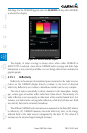
The following may cause abnormalities in displayed NEXRAD radar images:
•Groundclutter
•Strobesandspuriousradardata
•Sunstrobes(whentheradarantennapointsdirectlyatthesun)
•Interferencefrombuildingsormountains,whichmaycauseshadows
•Metallicdustfrommilitary aircraft, which can cause alterations in radar
scans