


x
Garmin G500 Pilot’s Guide
190-01102-02 Rev. B
Foreword
Sec 1
System
Sec 2
PFD
Sec 3
MFD
Sec 4
Hazard
Avoidance
Sec 5
Additional
Features
Sec 6
Annun.
& Alerts
Sec 7
Symbols
Sec 8
GlossaryAppendix A
Appendix B
Index
4.2.2 Terrain Proximity Limitations ..................................................4-8
4.2.3 System Status ........................................................................4-8
4.3 External TAWS ......................................................................................4-9
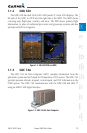
4.4 Garmin Terrain-SVT™ (Optional) .........................................................4-10
4.4.1.1 Garmin Terrain-SVT™ Page 120° Arc or 360° Rings .............4-11
4.4.1.2 Garmin Terrain-SVT™ Page Aviation Data ............................4-12
4.4.1.3 Inhibiting/Enabling Garmin Terrain-SVT™ Alerting ...............4-12
4.4.1.4 Synthetic Vision Alerts and Annunciations .............................4-13
4.5 TAS Traffic (Optional) ...........................................................................4-15
4.5.1 Displaying and Operating Traffic (TAS Systems) .....................4-15
4.5.1.1 Switching from Standby Mode to Operating Mode ...............4-15
4.5.1.2 Range Ring .........................................................................4-16
4.5.2 Altitude Display ...................................................................4-17
4.5.3 TAS Symbology ....................................................................4-18
4.5.4 Traffic System Status ............................................................4-19
4.5.5 Traffic Pop-Up......................................................................4-21
4.6 TIS Traffic (Optional) ............................................................................4-22
4.6.1 Traffic Map Page..................................................................4-22
4.6.2 TIS Symbology .....................................................................4-24
4.6.3 TIS Limitations .....................................................................4-25
4.6.4 TIS Alerts .............................................................................4-27
4.6.5 Traffic Pop-Up......................................................................4-28
4.6.6 TIS System Status ................................................................4-28
4.7 XM Weather (Optional) .......................................................................4-31
4.7.1 Using XM Satellite Weather Products ...................................4-31
4.7.2 Customizing the XM Weather Map ......................................4-31
4.7.3 XM Weather Symbols and Product Age ................................4-34
4.7.4 Weather Legends ................................................................4-36
4.7.5 NEXRAD .............................................................................4-37
4.7.5.1 Reflectivity ..........................................................................4-38
4.7.5.2 NEXRAD Limitations ............................................................4-39
4.7.6 Weather Page Map Orientation ............................................4-40
4.7.7 NEXRAD Data Viewing Range ..............................................4-40
4.7.8 NEXRAD Legend..................................................................4-41
4.7.9 Echo Tops ............................................................................4-42
4.7.10 Cloud Tops ..........................................................................4-44
4.7.11 XM Lightning ......................................................................4-46
4.7.12 Cell Movement ....................................................................4-47