


4-44
Garmin G500 Pilot’s Guide
190-01102-02 Rev. B
Foreword
Sec 1
System
Sec 2
PFD
Sec 3
MFD
Sec 4
Hazard
Avoidance
Sec 5
Additional
Features
Sec 6
Annun.
& Alerts
Sec 7
Symbols
Sec 8
GlossaryAppendix A
Appendix B
Index
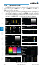
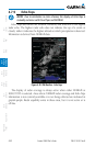
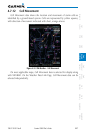
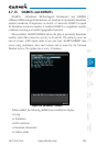
4.7.10 Cloud Tops
NOTE: Due to similarities in color schemes, the display of Cloud Tops is
mutually exclusive with Echo Tops and NEXRAD.
Cloud Tops data depicts cloud top altitudes as determined from satellite
imagery.
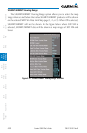
Figure 4-30 XM Weather - Cloud Tops
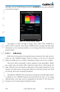
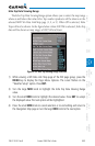
To display the Cloud Tops legend, select the LEGEND soft key when Cloud
Tops is selected for display. Since Cloud Tops and Echo Tops use the same color
scaling to represent altitude, display of these weather products is mutually
exclusive. When Cloud Tops is activated, Echo Tops or NEXRAD data is not
shown.