


4-4
Garmin G500 Pilot’s Guide
190-01102-02 Rev. B
Foreword
Sec 1
System
Sec 2
PFD
Sec 3
MFD
Sec 4
Hazard
Avoidance
Sec 5
Additional
Features
Sec 6
Annun.
& Alerts
Sec 7
Symbols
Sec 8
GlossaryAppendix A
Appendix B
Index
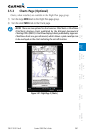
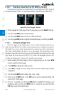
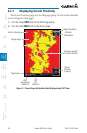
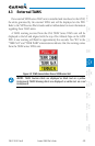
4.2.1 Displaying Terrain Proximity
The Terrain Proximity page is in the Map page group. Terrain is also selectable
on the Navigation Map pages.
1) Turn the Large MFD knob to the MAP page group.
2) Turn the small MFD knob to the Terrain page.
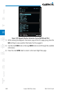
Map Orientation
North Indication
Range Rings
Altitude
Information
Terrain
Altitude
Legend
Ownship Symbol
at Present Position
360°
Range Ring
Selection
120°
Arc
Selection
Page Name
Figure 4-1 Terrain Page with Aviation Data Displayed and 360° View