


4 - FLIGHT PLANS
76
190-00356-00 Rev E
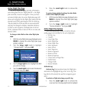
Active Flight Plan Options
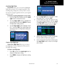
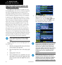
To determine the closest point, along the active
flight plan, to a selected waypoint:
1. Select the “Closest Point of FPL?” option from
the active flight plan page options and press
ENT.
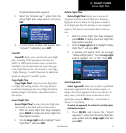
2. A window will appear with the reference
waypoint field highlighted. Use the small and
large right knobs to enter the identifier of the
reference waypoint and press ENT.
3. A confirmation window will appear for the
selected reference waypoint. Press ENT to
accept the waypoint.
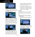
4. The 400W-series will display the bearing (BRG)
and distance (DIST) to the closest point along
the flight plan, from the selected reference
waypoint. To create a user waypoint at this
location and add it to the flight plan, highlight
“Load?” and press ENT. The name for the new
user waypoint will be derived from the identi-
fier of the reference waypoint.
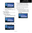
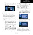
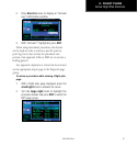
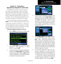
Parallel Track
Parallel Track? allows you to create a parallel
course offset of 1 to 99 NM to the left or right of your
current flight plan. After setting a parallel track to your
current flight plan, a magenta parallel track line will be
drawn offset from the original by the selected distance.
The original course line will be drawn in white. The
aircraft will navigate to the parallel track course line.
When you reach the end of the flight plan, an
annunciatormessagewillstate“PTKENDXS”.The
message will give the pilot sufficient time to intercept
the original course.
Points to remember with Parallel Track:
• Youmusthaveanactiveightplan
• Thecurrentlegmustsupportparalleltrack
• Parallel track is not allowed for the active leg of an
approach
• Paralleltrack is not allowed if the active leg is not a
track-to-fix or direct-to-fix leg
• Paralleltrackmaybeallowedbutnottheselected
offset distance
TO
WPT
FROM
WPT
North
BRG
Parallel Track Distance
Course
DTK
Offset
TO
WPT
Offset
FROM
WPT