


APPENDIX C
Troubleshooting Q & A
200
190-00356-00 Rev E
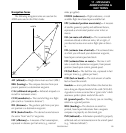
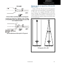
How do I skip a waypoint in an approach, departure,
or arrival?
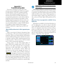
The 400W-series unit allows you to manually select
any approach, departure or arrival leg as the active leg of
your flight plan. This procedure is performed from the
active flight plan page by highlighting the desired waypoint
and pressing direct-to twice, then ENT to approve the se-
lection (see illustration right). The GPS will then provide
navigation along the selected flight plan leg, so be sure
you have clearance to that position.
NOTE: If activating a leg while on the From side,
sequencing will be suspended as indicated with
the SUSP annunciation shown above the OBS
key.
How do I fly the GPS with an autopilot and DG head-
ing bug?
If you do not have an HSI, you should make your
courseselectionsontheexternalCDI’sOBS knob and the
DGheadingbug.
When does turn anticipation begin, and what bank
angle is expected?
The 400W-series unit will smooth adjacent leg transi-
tions based upon a nominal 15º bank angle (with the abil-
ity to increase the bank angle up to 30º) and provide three
pilot cues for turn anticipation:
1) A waypoint alert (“LT or RT to ###° x S”) will flash
in the lower right corner of the screen 10 seconds
before the turn point.
2) A flashing turn advisory (“LT or RT TO ###° NOW”)
will appear in the lower right corner of the screen
when you are to begin the turn. Set the HSI to the
nextDTKvalueandbegintheturn.
3)TheTo/Fromindicatoron theHSI(or CDI)will
flip momentarily to indicate that you have crossed
the midpoint of the turn. For more information on
waypoint alerts and turn advisories, see section 5.
When does the CDI scale change, and what does it
change to?
TheCDIscaleis1.0NM(terminalmode)within31
NMofthedepartureairport.TheCDIwillsmoothlyscale
to 2.0 NM (en route mode) once beyond 31 NM from the
departure airport.
TheunitbeginsasmoothCDIscaletransitionfromthe
2.0 NM (en route mode) to the 1.0 NM (terminal mode)
scale within 31 NM from the destination airport. When
within 45° of the final approach course and the FAF is
the TO waypoint, the 400W-series unit switches from ter-
minalmodetoapproachmode.CDIscalingistightened
from 1.0 NM full scale deflection to either 0.3 NM or 2°
full scale deflection whichever is less at the FAF. The scal-
ing change occurs gradually over a 2 NM distance and is
completed before crossing the FAF.
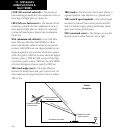
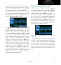
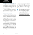
IfVectorsto Finalisselected,theunit providesCDI
scaling appropriate to the approach, which is typically ±2
degrees angular from the origin of the approach. This an-
gular course deviation reaches the max ±1 NM deviation
at approximately 27 NM from the MAP. The course width
and angular deviation for GPS approaches are similar to
whatisprovidedforVHF localizersignals.(seetheg-
ure–Full-ScaledeectionanddenedpathforVTFap-
proach).
Ifa missedapproachis executed,the CDIscalewill
change to ±0.3 NM or ±1.0 NM, as described in Section
5 - Procedures - Flying the Missed Approach.