


2 - NAV PAGES
42
190-00356-00 Rev E
NOTE: The data contained in the TERRAIN databases
comes from government agencies. Garmin accurately
processes and cross-validates the data but cannot
guarantee the accuracy and completeness of the data.
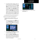
TERRAIN Alerting
TERRAIN uses information provided from the GPS
receiver to provide a horizontal position and altitude.
GPS altitude is derived from satellite measurements. GPS
altitude is converted to a mean sea level (MSL)-based
altitude (GPS-MSL altitude) and is used to determine
TERRAIN alerts. GPS-MSL altitude accuracy is affected
by factors such as satellite geometry, but it is not subject
to variations in pressure and temperature that normally
affect pressure altitude devices. GPS-MSL altitude does
not require local altimeter settings to determine MSL
altitude. Therefore, GPS altitude provides a highly accurate
and reliable MSL altitude source to calculate terrain and
obstacle alerts.
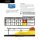
TERRAIN utilizes terrain and obstacle databases that
are referenced to mean sea level (MSL). Using the GPS
positionandGPS-MSLaltitude,TERRAINdisplaysa2-D
picture of the surrounding terrain and obstacles relative
to the position and altitude of the aircraft. Furthermore,
the GPS position and GPS-MSL altitude are used to
calculate and “predict” the aircraft’s flight path in relation
to the surrounding terrain and obstacles. In this manner,
TERRAIN can provide advanced alerts of predicted
dangerous terrain conditions. Detailed alert modes are
described later in this section.
Baro-Corrected Altitude
Baro-corrected altitude (or indicated altitude) is derived
by adjusting the altimeter setting for local atmospheric
conditions. The most accurate baro-corrected altitude
can be achieved by frequently updating the altimeter
setting to the nearest reporting station along the flight
path. However, because actual atmosphere conditions
seldom match the standard conditions defined by the
International Standard Atmosphere (ISA) model (where
pressure, temperature, and lapse rates have fixed values),
it is common for the baro-corrected altitude (as read from
the altimeter) to differ from the GPS-MSL altitude. This
variation results in the aircraft’s true altitude differing from
the baro-corrected altitude.
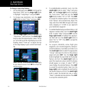
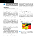
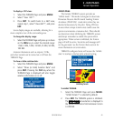
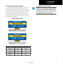
Terrain Page
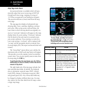
TodisplaytheTERRAINPage,selecttheNAV
group and turn the small right knob until the
TERRAIN Page is displayed. The page displays terrain
information, aircraft ground track, and GPS-derived
MSL altitude. Altitude is shown in increments of 20
feet or in increments of 10 meters, depending on unit
configuration. The “G” to the right of the MSL altitude
display reminds the pilot that altitude is GPS-derived.
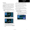
The TERRAIN Page has two selectable view
settings:
• 360˚ View—Viewfromaboveaircraftdepicting
surrounding terrain on all sides
• 120˚ View—Viewofterrainaheadofand60˚to
either side of the aircraft flight path
TERRAIN Page
NOTE: The TERRAIN Page gives a “Track Up” dis-
play orientation, as indicated by the “TRK” label
shown on the display. This is the only orientation
available on this page.
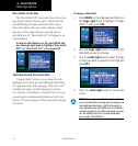
Terrain Operation