


14
TAKEOFF TOUR
190-00356-00 Rev E
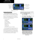
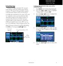
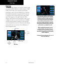
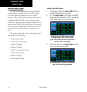
Map Page
The map page displays your present position (using
anairplanesymbol)relativetonearbyairports,VORs,
NDBs,intersections,userwaypointsandairspace
boundaries—and your route displayed as a solid line.
Dataeldsfordestinationwaypoint(WPT),distance
towaypoint(DIS),desiredtrack(DTK)andground
speed (GS) appear on the right hand side of the
display. These fields are user-selectable to allow you to
configure the unit to your own preferences. Available
settings include: altitude, bearing, en route safe alti-
tude, estimated time of arrival, minimum safe altitude,
and ground track. See Section 11 for definitions of
these navigation terms.
Map Page
Data
Fields
Present
Position
Map Display
Map
Scale with
declutter
value
Desired Track
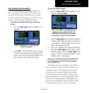
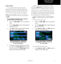
The map page combines a moving map
display and navigation data for complete
situational awareness. Map setup pages
are provided to designate the maximum
scale at which each map feature will ap-
pear. These settings provide an automatic
decluttering of the map (based upon your
preferences) as you adjust the scale.
While viewing the map page, you can
quickly declutter and remove many of
the background map details by pressing
the CLR key (repeatedly) until the desired
detail is depicted.
To change the map scale, press the or
sides of the RNG key.
Map Page