


2 - NAV PAGES
36
190-00356-00 Rev E
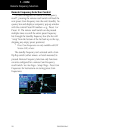
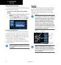
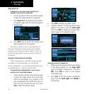
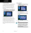
Map Direct-To
To designate an on-screen airport, navaid or user
waypoint as your direct-to destination:
1. Use the panning function (see previous page)
to place the target pointer on a waypoint.
2. Press direct-to key to display the select direct-
to waypoint page, with the selected waypoint
already listed.
3. Press ENT twice to confirm the selection and
begin navigating to the waypoint.
The direct-to function can be used anywhere on
the map. If nothing currently exists at the crosshair
position, a new waypoint (called “+MAP”) will be cre-
ated at the target pointer location before the direct-to
is initiated.
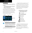
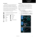
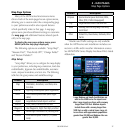
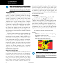
Airspace Information on the Map
When a special-use or controlled airspace bound-
ary appears on the map display, you can quickly
retrieve information — such as floor/ceiling limits and
controlling agency — directly from the map.
To view airspace information for an on-screen
special-use or controlled airspace:
1. Use the panning function (see previous page)
to place the target pointer on an open area
within the boundaries of an airspace. If the
area is congested and it is difficult to select an
open area, you may need to zoom in or press
CLR to make the selection easier.
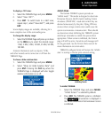
2. Press ENT to display an options menu.
3. “Review Airspace?” should already be high-
lighted, if not select it with the small right
knob. Press ENT to display the airspace infor-
mation page for the selected airspace.
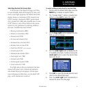
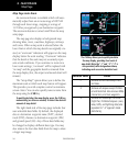
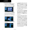
To display airspace frequencies:
1. While viewing the airspace information display
in the above example, turn the large right
knob to highlight “Frequencies?” and press
ENT. Press CLR to return to the airspace
information page.
2. Press CLR to exit the airspace information
page. Press the small right knob (CRSR) to
exit panning.
Map Page