


2 - NAV PAGES
39
190-00356-00 Rev E
Map Page Options
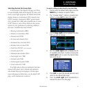
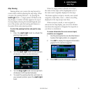
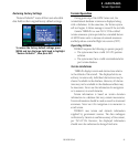
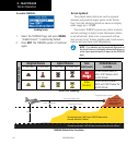
7. For airspace boundaries, highways, roads, rail-
road lines, wind vector, active flight plan course
lines, and lat/long grid lines: turn the small
right knob to select the appropriate “Group”
name (per the chart on the previous page)
and press ENT. Use the large right knob to
highlight the zoom field for the desired feature
and turn the small right knob to select the
maximum scale at which the feature should
appear on screen. Or select “Off” to never dis-
play the selected feature. Press ENT to accept
the selected option. Distance Measurements
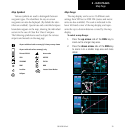
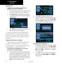
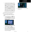
The“MeasureDist?” option provides a quick, easy
method for determining the bearing and distance
between any two points on the map display.
To measure bearing and distance between two
points:
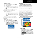
1. On the Nav Map page, press MENU. Then,
turn the large right knob to highlight “Mea-
sure Dist?” and press ENT. An on-screen refer-
ence pointer will appear on the map display at
your present position.
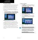
2. Use the small and large right knobs to place
the reference pointer at the location you wish
to measure FROM and press ENT.
3. Again, use the small and large right knobs to
place the reference pointer at the location you
wish to measure TO. The bearing and distance
from the first reference location will appear at
the top of the map display.
4. To exit the “Measure Dist?” option, press the
small right knob.