


6 - WPT PAGES
129
190-00356-00 Rev E
Intersections
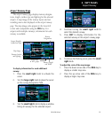
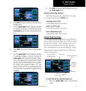
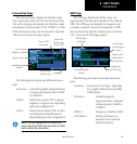
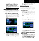
Intersection Page
The intersection page displays the latitude, longi-
tude, region and country for the selected intersection.
The intersection page also displays the identifier, radial
anddistancefromthenearestVOR,VORTACorVOR/
DME.Intersectionsmayonlybeselectedbyidentier.
There are no Intersection page options.
Nearest VOR
and Symbol
Intersection
Identifier and Symbol
Region/Country
Seventh Page
in WPT group
Latitude/Longitude
Position
Radial and
Distance from
Nearest VOR
The following descriptions and abbreviations are
used:
•Position— Latitude/Longitude(degrees/minutes
or degrees/minutes/seconds), MGRS
or UTM/UPS
•RAD— RadialfromnearestVORindegrees
magnetic or degrees true (depending
upon unit configuration)
•DIS— DistancefromnearestVOR,innauti-
cal miles/statute miles/kilometers
(depending upon unit configuration)
NOTE: The VOR displayed on the intersection
page is the nearest VOR, not necessarily the VOR
used to define the intersection.
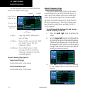
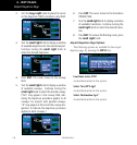
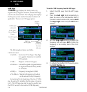
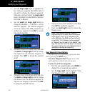
NDB Page
The NDB page displays the facility name, city,
region/country, latitude and longitude for the selected
NDB.TheNDB page also displays the frequency and
aweatherbroadcastindication(ifapplicable).NDBs
may be selected by identifier, facility name or location
(city).TherearenoNDBpageoptions.
Facility Name,
City and Region/
Country
NDB Identifier
and Symbol
Eighth Page
in WPT group
Latitude/Longitude
Position
Frequency and
Weather Broad-
cast Indication
The following descriptions and abbreviations are
used:
•Symbol— SeeSection2NavPages-MapPage
for a graphic illustration of available
NDBsymbols
•Position— Latitude/Longitude
(degrees/minutes or degrees/
minutes/seconds), MGRS or
UTM/UPS
•FREQ— Frequencyinkilohertz(kHz)
•WxBrdcst— Weatherinformationis
broadcast on the selected
facility’s frequency