


6 - WPT PAGES
120
190-00356-00 Rev E
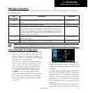
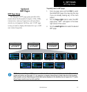
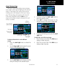
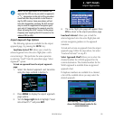
Airport Location
Airport Location Page
The airport location page displays the latitude, lon-
gitude, and elevation of the selected airport. The air-
port location page also displays facility name and loca-
tion, as well as fuel availability, available approaches,
radar coverage and airspace type.
Facility Name and
Location (city)
Airport Identifier,
Symbol and Type
Latitude/Longi-
tude Position
First Page
in WPT group
Best Available
Approach and
Radar Coverage
Field Elevation,
Available Fuels and
Airspace Type
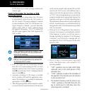
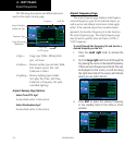
The following descriptions and abbreviations are
used:
•Type— Usagetype:Public,Military,Heliport,
or Private
•Position— Latitude/Longitude(degrees/minutes
or degrees/minutes/seconds), MGRS
or UTM/UPS
•Elevation—Infeetormeters
•Fuel— Forpublic-useairports,theavail-
able fuel type(s) are: Avgas (80-
87/100LL/100-130/Mogas), Jet, or
None
•Approach—Bestavailableapproach:ILS,
MLS,LOC,LDA,SDF,GPS,VOR,
RNAV(“RNV”),LORAN(“LOR”),
NDB,TACAN(“TCN”),Helicopter
(“HEL”),orVFR
•Radar— Radarcoverage:YesorNo
•Airspace— Controlenvironment:CTA,TMA,
TRSA,ClassB,ClassC,ClassD,or
none
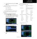
Airport Location Page Options
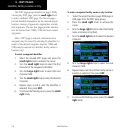
Select Next FPL Apt?
Selecting the Next Airport page menu option
allows you to display the next waypoint in the
flight plan and activates it for editing.
To select the next FPL airport from the Airport
Location Page:
1. Press MENU to display the Airport Location
Page Options.
2. Turn the small or large right knob to high-
light “Select Next FPL Apt? and then press
ENT.
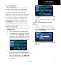
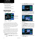
Select Destination Apt?
SelectingtheDestinationAirportpagemenuoption
allowsyoutodisplaytheDestinationwaypointin
the flight plan.
To select the Destination airport from the Airport
Approach Page:
1. Press MENU to display the Airport Approach
Page Options.
2. Turn the small or large right knob to high-
light “Select Destination Apt? and then press
ENT.