


5 - PROCEDURES
93
190-00356-00 Rev E
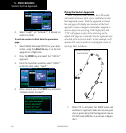
Approach with Hold
NOTE: If you need to lose extra altitude or speed
by going around the holding pattern again, press
OBS to manually suspend waypoint sequencing
BEFORE crossing the holding waypoint the second
time. If you’ve already passed this waypoint, re-
activate the holding pattern.
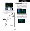
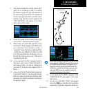
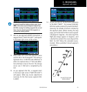
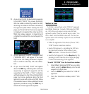
11. Also as you approach BODRY intersection, a
waypoint alert (”NEXT DTK 209°”) will appear
in the lower right corner of the screen.
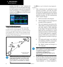
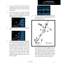
12. When within 45° of the final approach course
and the FAF is the TO waypoint. CDI scaling is
tightened from 1.0 NM full scale deflection to
either 0.3 nautical mile or 2° full scale deflec-
tion whichever is less at the FAF. The change
occurs over 2 NM and is completed by the
FAF.
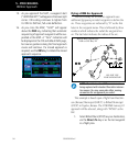
13. As you approach the FAF, a waypoint alert
in the lower right corner (“NEXT DTK 209°”)
will appear. Make any course adjustments
necessary for the final course segment (FAF
to MAP).
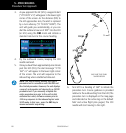
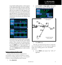
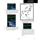
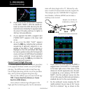
14. As you cross the FAF, the destination sequences
to the MAP (“RW21”, the runway threshold).
With the needle centered, fly toward the MAP,
observing the altitude minimums dictated by
the approach plate. (When viewing the map
page, you’ll note that the final course segment
is displayed in magenta—the active leg of the
flight plan always appears in magenta—and
a dashed line extends the course beyond the
MAP. Do NOT follow this extended course.
Instead, follow published missed approach
procedures.)
DO NOT USE FOR
NAVIGATION