


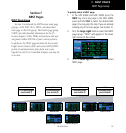

6 - WPT PAGES
131
190-00356-00 Rev E
User Waypoints
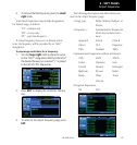
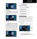
User Waypoint Page
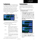
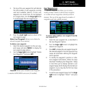
Inadditiontotheairport,VOR,NDBandintersec-
tioninformationcontainedinyourJeppesenNavData
®
card, the 400W-series units allow you to store up to
1,000 user-defined waypoints. The user waypoint
page displays the waypoint name (up to five charac-
ters long), identifier and radial from two reference
waypoints, distance from one reference waypoint, along
with the user waypoint’s latitude/longitude position.
Reference
Waypoint
Information
User Waypoint
Name
Tenth Page
in WPT group
Latitude/Longitude
Position
Create/Modify
Action Field
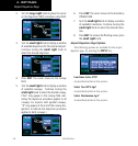
The following descriptions and abbreviations
appear on the user waypoint page:
•REFWPT— Reference waypoint identifier
(name)
•RAD— Radialfromreferencewaypoint,in
degrees magnetic or degrees true
(depending upon unit configuration)
•DIS— Distancefromreferencewaypoint,in
nautical miles/statute miles/kilome-
ters (depending upon unit configura-
tion)
•Position— Latitude/Longitude(degrees/minutes
or degrees/minutes/seconds), MGRS
or UTM/UPS
User waypoints may only be selected by name (iden-
tifier), as described
in the beginning of Section 6
.
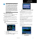
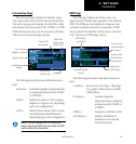
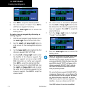
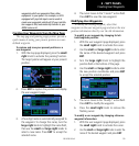
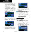
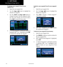
Creating User Waypoints
User waypoints may be created from the user
waypoint page or the map page. To create a new user
waypoint, simply enter its name (identifier) and
position, or reference another waypoint by radial and
distance.
To create a new user waypoint by entering its
latitude/longitude position:
1. With the user waypoint page displayed, press
the small right knob to activate the cursor.
2. Use the small and large right knobs to enter
a name for the new waypoint and press ENT.
Your present position appears in the position
field at the bottom of the page. To create a
waypoint at your present position, turn the
large right knob to highlight “Create?” and
skip to step #6.
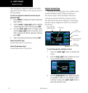
3. Turn the large right knob to highlight the
position field at the bottom of the page.
4. Use the small and large right knobs to
enter the position coordinates for the new
waypoint.