


11 - MESSAGES
ABBREVIATIONS &
NAV TERMS
194
190-00356-00 Rev E
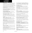
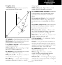
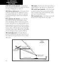
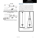
VERTICAL NAVIGATION PROFILE
VERTICAL SPEED REQUIRED
DISTANCE TO TARGET
TIME AND DISTANCE
TO PROFILE
TARGET ALTITUDE
AND POSITION
AIRPORT
CURRENT ALTITUDE
AND POSITION
Vertical
Navigation
LFOB (left-over fuel onboard)— The amount of
fuel remaining on board after the completion of one or
more legs of a flight plan (or a direct-to).
LRES (left-over fuel reserve)— The amount of fuel
remaining on board after the completion of a one or
more legs of a flight plan (or a direct-to), expressed
in time and based upon a known fuel consumption
(flow) rate.
MSA (minimum safe altitude)— Uses Grid Mini-
mum Off-route Altitudes (Grid MORAs) to deter-
mine a safe altitude within ten miles of your present
position. Grid MORAs are one degree latitude by one
degree longitude in size and clear all reference points
within the grid by 1000 feet in areas where the highest
reference point is 5000 feet MSL or lower. If the high-
est reference point is above 5000 feet, the Grid MORA
will clear the highest reference point by 2000 feet.
TKE (track angle error)— The angle difference
between the desired track and your current track. An
arrow indicates the proper direction to turn to reduce
TKE to zero.
TRK (track)— The direction of movement relative to
a ground position. Also referred to as “ground track”.
VSR (vertical speed required)— The vertical speed
necessary to descend from current position and alti-
tude to a defined target position and altitude, based
upon your current ground speed.
XTK (crosstrack error)— The distance you are off a
desired course in either direction, left or right.