


5 - PROCEDURES
110
190-00356-00 Rev E
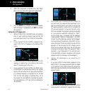
4. After the approach is loaded into the flight
plan, you can view the approach waypoints.
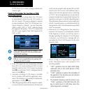
5. Press the PROC key to display the Procedures page.
With “Activate?” highlighted press ENT to activate
the approach.
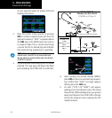
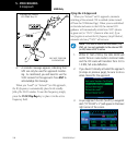
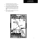
Flying the LPV Approach
1. Within 31 NM of KSLE, the 400W Series unit switches
from en route mode to terminal mode and the CDI
scale transitions from 2.0 to 1.0 NM, full scale deflec-
tion.
2. As you approach the IAF (GLORR), a waypoint mes-
sage (“LT TO 314° x S”) appears on the bottom of the
screen.
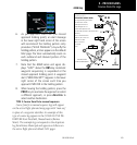
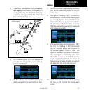
3. As the distance (DIST) to the IAF approaches zero, the
message is replaced by a turn advisory that counts
down 10 seconds prior to the turn.
4. As you approach the FAF (LOTKE), the 400W Series
unit will begin to automatically rescale in an angular
fashion. This will allow the LPV approach to be flown
in an identical fashion to a standard ILS. At 2.0 NM
from the FAF, CDI scaling is tightened from 1.0 to
the angular full scale deflection (typically the angular
full-scale deflection is 2.0°, but will be as defined for
the approach.
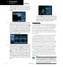
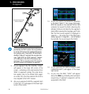
5. Sixty seconds prior to reaching the FAF (LOTKE), the
unit will check the required Horizontal Alarm Limit
(HAL) and Vertical Alarm Limit (VAL) to ensure the
GPS position integrity is within limits to complete the
LPV precision approach. In the event the HAL or VAL
limits are exceeded, the approach will be downgraded
to a non-precision approach indicated by “LNAV”
on the moving map, a message that the approach
is downgraded (“Approach downgraded - Use LNAV
minima”), and the glideslope indicator will be flagged.
You may continue the approach using LNAV non-pre-
cision minimums if there are LNAV minimums for this
approach. In the rare event the GPS integrity cannot
meet the non-precision HAL limits, the unit will send
a message to the pilot to abort the approach (“Abort
Approach - Loss of Navigation”). The unit will revert
to terminal limits to support navigation to the missed
approach when the message is acknowledged. \
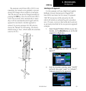
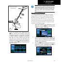
6. Capture the glideslope as you would an ILS
glideslope.
7. As you cross LOTKE, the destination sequences to the
MAP (“RW31”, the runway threshold). With the needle
on the external CDI (or HSI) centered, fly toward the
MAP, observing the altitude minimums dictated by the
approach plate.
8. When viewing the Map Page, you’ll note that the final
course segment is displayed in magenta (the active leg
LPV Approach