


2 - NAV PAGES
55
190-00356-00 Rev E
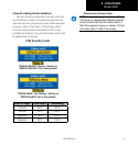
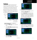
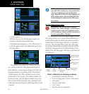
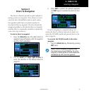
Satellite Status Page
Satellite Status Page
The Satellite Status Page is helpful in troubleshoot-
ing weak (or missing) signal levels due to poor satellite
coverage or installation problems. You may wish to
refer to this page occasionally to monitor GPS receiver
performance and establish a normal pattern for system
operation. Should problems occur at a later date, you
may find it helpful to have an established baseline
from which to compare.
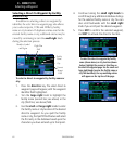
GPS Receiver
Status
Sky View
of satellite
positions
Signal
Strength Bars
Page location
in NAV group
Satellite
Numbers
Horizontal Figure of Merit
and Vertical Figure of Merit
Estimated Posi-
tion Uncertainty
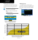
Acquiring
Satellite,
not ready
for use
Excluded
Satellite
(cyan)
Satellite
acquired
and used for
position fix
(green)
Satellite acquired, used for
position fix, and has differential
corrections
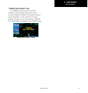
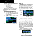
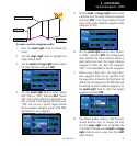
As the GPS receiver locks onto satellites, a signal
strength bar appears for each satellite in view, with the
appropriate satellite number (01-32, WAAS satellites
will have higher numbers) underneath each bar. The
progress of satellite acquisition is shown in the follow-
ing conditions:
• Hollowsignalstrengthbars—thereceiverhasfound
the satellite(s) and is collecting data.
• Cross-hatchcyansignalstrengthbars—thereceiver
has found the satellite(s) but it has been excluded
bytheFDEprogramasafaultysatellite.
• Solidcyansignalstrengthbars—thereceiverhas
collected the necessary data, but is not using the
satellite in the position solution.
• Solidgreensignalstrengthbars—thereceiverhas
collected the necessary data and the satellite is being
used in the position solution. The sky view display
(at top left corner of the page) shows which satel-
lites are currently in view, and where they are. The
outer circle of the sky view represents the horizon
(with north at top of the page); the inner circle 45°
above the horizon; and the center point directly
overhead.
The“D”characterinsidethebarsindicatesdiffer-
ential corrections (e.g. WAAS) are being used for that
satellite.
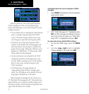
Each satellite has a 30-second data transmission
that must be collected (hollow signal strength bar)
before the satellite may be used for navigation (solid
signal strength bar). Once the GPS receiver has deter-
mined your position, the 400W-series unit indicates
your position, altitude, track and ground speed. The
GPS receiver status field also displays the following
messages under the appropriate conditions:
•Searching Sky —
The GPS receiver is searching the sky for ANY vis-
ible satellites. You are also informed of this status
with a “Searching the Sky” message.
•AcquiringSat —
The GPS receiver is acquiring satellites for naviga-
tion. In this mode, the receiver uses satellite orbital
data (collected continuously from the satellites) and
last known position to determine the satellites that
should be in view.