


2 - NAV PAGES
33
190-00356-00 Rev E
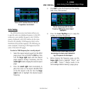
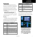
Map Page
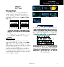
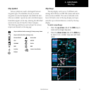
Map Symbols
Various
symbols are used to distinguish between
waypoint types. The identifiers for any on-screen
waypoints can also be displayed. (By default the iden-
tifiers are enabled). Special-use and controlled airspace
boundaries appear on the map, showing the individual
sectors in the case of Class B or Class C airspace.
The following symbols are used to depict the various
airports and navaids on the map page:
Airport with hard surface runway(s); Primary runway shown
Airport with soft surface runway(s) only
Private Airfield Intersection
VOR VORTAC
VOR/DME TACAN
DME NDB
Localizer Locator Outer Marker
Heliport
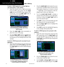
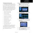
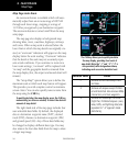
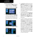
Map Range
The map display can be set to 23 different scale
settings from 500 feet to 2000 NM (statute and metric
units are also available). The scale is indicated in the
lower left-hand corner of the map display, and repre-
sents the top-to-bottom distance covered by the map
display.
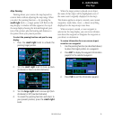
To select a map Range:
1. Press the up arrow side of the RNG key to
zoom out to a larger map area.
2. Press the down arrow side of the RNG key
to zoom in to a smaller map area and more
detail.