


2 - NAV PAGES
52
190-00356-00 Rev E
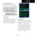
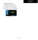
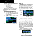
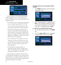
Position Page
Some listed frequencies may include designations
for limited usage, as follows:
“TX”-transmitonly
“RX”-receiveonly
“PT” - part time frequency
If a listed frequency has sector or altitude restric-
tions, the frequency will be preceded by an “Info?”
designation.
To view usage restrictions for a frequency:
1. Turn the large right knob to place the cursor
on the “Info?” designation directly in front of
the desired frequency.
2. Press ENT to display the restriction informa-
tion.
3. To return to the NAVCOM page, press ENT.
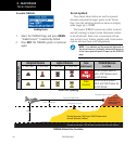
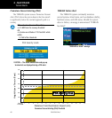
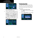
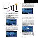
Position Page
The position page displays your present position (by
default, in latitude and longitude) and altitude. The
position page also displays your current track, ground
speed, time and a reference waypoint field. These
fields are user-selectable to configure the page to your
own preferences and current navigation needs.
User-selectable
Data Fields
Graphic “Track”
Indicator
Present
Position
Page location in
NAV group
Reference
Waypoint Fields
The graphic “track” indicator at the top of the
page indicates the direction you’re heading, or track,
onlywhileyou’removing.Directlybelowarethree
user-selectable fields, which by default, display track,
ground speed and altitude. Minimum safe altitude
(MSA) can also be displayed on these fields. MSA is
the recommended minimum altitude within approxi-
mately ten miles of your present position. MSA is cal-
culated from the information contained in the database
and generally includes mountains, buildings and other
permanent features.
The Time and other data may not be displayed
until the unit has acquired enough satellites for a fix.
The graphic “track” indicator and the TRK
indication directly below it provide the same
information. Use the graphic “track” indicator
for quick at-a-glance ground track information.