


190-00595-01 Rev. B
Garmin G1000 Pilot’s Guide for the Beechcraft A36/G36
SYSTEM
OVERVIEW
FLIGHT
INSTRUMENTS
EIS
AUDIO PANEL
& CNS
FLIGHT
MANAGEMENT
HAZARD
AVOIDANCE
AFCS
ADDITIONAL
FEATURES
APPENDICES INDEX
459
APPENDIX B
The obstacle database contains data for obstacles, such as towers, that pose a potential hazard to aircraft.
Obstacles 200 feet and higher are included in the obstacle database. It is very important to note that not all
obstacles are necessarily charted and therefore may not be contained in the obstacle database. This database is
updated on a 56-day cycle.
NOTE: The data contained in the terrain and obstacle databases comes from government agencies. Garmin
accurately processes and cross-validates the data, but cannot guarantee the accuracy and completeness of
the data.
The SafeTaxi database contains detailed airport diagrams for selected airports. These diagrams aid in following
ground control instructions by accurately displaying the aircraft position on the map in relation to taxiways,
ramps, runways, terminals, and services. This database is updated on a 56-day cycle.
The FliteCharts database contains procedure charts for the United States only. This database is updated on a
28-day cycle. If not updated within 180 days of the expiration date, FliteCharts will no longer function.
UPDATING GARMIN DATABASES
The Garmin database updates can be obtained by following the instructions detailed in the ‘Aviation
Databases’ section of the Garmin website (www.garmin.com). Once the updated files have been downloaded
from the website, a PC equipped with an appropriate SD card reader is used to unpack and program the
new databases onto the existing Supplemental Data Cards. Equipment required to perform the update is as
follows:
• Windows-compatible PC computer (Windows 2000 or XP recommended)
• SanDisk SD Card Reader, P/Ns SDDR-93 or SDDR-99 or equivalent card reader
• Updated database obtained from the Garmin website
• Existing 010-00330-42 Supplemental Database SD Cards from both PFD and MFD
In some cases it may be necessary to obtain an unlock code from Garmin in order to make the database
product functional. It may also be necessary to have the system configured by a Garmin authorized service
facility in order to use some database features.
After the data has been copied to the appropriate data cards, perform the following steps:
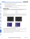
1) Insert one SD card in the bottom card slot of the MFD and one in the bottom card slot of each PFD. The SD card
containing the ChartView or FliteCharts database must be inserted into the bottom slot on the MFD.
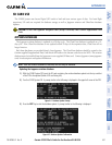
2) Apply power to the G1000 System. View the MFD power-up splash screen. Check that the databases are
initialized and displayed on the splash screen. When updating the terrain and FliteCharts databases, an ‘in
progress’ message may be seen. If this message is present, wait for the system to finish loading before verifying
the correct databases are initialized, then proceed to step 3.