


Garmin G1000 Pilot’s Guide for the Beechcraft A36/G36
190-00595-01 Rev. B386
ADDITIONAL FEATURES
SYSTEM
OVERVIEW
FLIGHT
INSTRUMENTS
EIS
AUDIO PANEL
& CNS
FLIGHT
MANAGEMENT
HAZARD
AVOIDANCE
AFCS
ADDITIONAL
FEATURES
APPENDICESINDEX
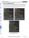
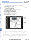
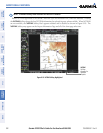
Selecting a chart:
1) While viewing the Navigation Map Page, Flight Plan Page, or Nearest Airports Page, press the SHW CHRT
Softkey. The airport diagram or approach chart is displayed on the Airport Information Page.
2) Press the
FMS
Knob to activate the cursor.
3) Turn the large FMS Knob to select either the Airport Identifier Box or the Approach Box. (Press the APR Softkey
if the Approach Box is not currently shown).
4) Turn the small and large FMS Knob to enter the desired airport identifier.
5) Press the ENT Key to complete the airport selection.
6) Turn the large FMS Knob to select the Approach Box.
7) Turn the small
FMS
Knob to show the approach chart selection choices.
8) Turn either
FMS
Knob to scroll through the available charts.
9) Press the ENT Key to complete the chart selection.
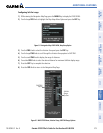
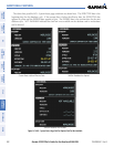
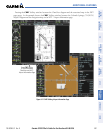
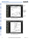
Figure 8-11 Approach Information Page, Chart Selection
Select Desired
Approach Chart
From Menu
Scroll Through
Entire Chart
With the
Joystick
Chart Scale
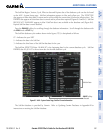
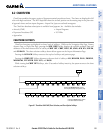
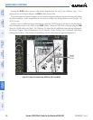
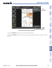
While the APPROACH Box is selected using the FMS Knob, the G1000 softkeys are blank. Once the desired
chart is selected, the chart scale can be changed and the chart page can be scrolled using the Joystick. Pressing
the Joystick centers the chart on the screen.
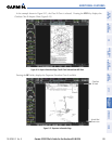
The aircraft symbol is shown on the chart only if the chart is to scale and the aircraft position is within
the boundaries of the chart. The aircraft symbol is not displayed when the Aircraft Not Shown Icon appears
(Figure 8-15). If the Chart Scale Box displays a banner NOT TO SCALE, the aircraft symbol is not shown. The
Aircraft Not Shown Icon may appear at certain times, even if the chart is displayed to scale.