


190-00595-01 Rev. B
Garmin G1000 Pilot’s Guide for the Beechcraft A36/G36
159
FLIGHT MANAGEMENT
SYSTEM
OVERVIEW
FLIGHT
INSTRUMENTS
EIS
AUDIO PANEL
& CNS
FLIGHT
MANAGEMENT
HAZARD
AVOIDANCE
AFCS
ADDITIONAL
FEATURES
APPENDICES INDEX
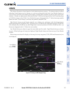
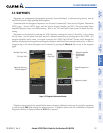
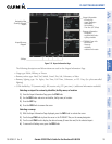
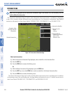
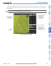
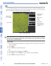
Figure 5-31 Airport Information Page
Airport/Runway
Diagram
Navigation Map
Showing Selected
Airport
Runway Information
- Designation
- Length/Width/Surface
- Lighting Available
Airport Information
- ID/Facility/City
- Usage Type/Region
- Lat/Long/Elev
- Fuel Available
- Time Zone (UTC Offset)
COM/NAV Freq. Info.
- Identification
- Frequency
- Availability
- Additional Information
Softkeys
The following descriptions and abbreviations are used on the Airport Information Page:
• Usage type: Public, Military, or Private
• Runway surface type: Hard, Turf, Sealed, Gravel, Dirt, Soft, Unknown, or Water
• Runway lighting type: No Lights, Part Time, Full Time, Unknown, or PCL Freq (for pilot-controlled
lighting)
• COM Availability: TX (transmit only), RX (receive only), PT (part time), i (additional information available)
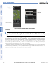
Selecting an airport for review by identifier, facility name, or location:
1) From the Airport Information Page, press the FMS Knob.
2) Use the FMS Knobs and enter an identifier, facility name, or location.
3) Press the ENT Key.
4) Press the FMS Knob to remove the cursor.
Selecting a runway:
1) With the Airport Information Page displayed, press the FMS Knob to activate the cursor.
2) Turn the large FMS Knob to place the cursor in the ‘RUNWAYS’ Box, on the runway designator.
3) Turn the small FMS Knob to display the desired runway (if more than one) for the selected airport.
4) To remove the flashing cursor, press the FMS Knob.