


Garmin G1000 Pilot’s Guide for the Beechcraft A36/G36
190-00595-01 Rev. B
300
HAZARD AVOIDANCE
SYSTEM
OVERVIEW
FLIGHT
INSTRUMENTS
EIS
AUDIO PANEL
& CNS
FLIGHT
MANAGEMENT
HAZARD
AVOIDANCE
AFCS
ADDITIONAL
FEATURES
APPENDICESINDEX
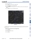
6.3 TERRAIN AWARENESS AND WARNING SYSTEM (TAWS)
WARNING: Do not use TAWS information for primary terrain avoidance. TAWS is intended only to enhance
situational awareness.
NOTE: The data contained in the TAWS databases comes from government agencies. Garmin accurately
processes and cross-validates the data but cannot guarantee the accuracy and completeness of the data.
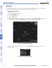
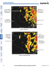
TAWS (Terrain Awareness and Warning System) increases situational awareness and aids in reducing controlled
flight into terrain (CFIT). TAWS provides visual and aural annunciations when terrain and obstacles are within
the given altitude threshold from the aircraft. The displayed alerts and warnings are advisory in nature only.
TAWS satisfies TSO-C151b Class B requirements for certification. Class B TAWS is required for all Part 91
aircraft operations with six or more passenger seats and for Part 135 turbine aircraft operations with six to nine
passenger seats (FAR Parts 91.223, 135.154).
TAWS requires the following to operate properly:
• A valid terrain/obstacle/airport terrain database
• A valid 3-D GPS position solution
TAWS uses terrain and obstacle information supplied by government sources. Terrain information is based on
terrain elevation information in a database that may contain inaccuracies. Individual obstructions may be shown
if available in the database. The data undergoes verification by Garmin to confirm accuracy of the content, per
TSO-C151b. However, the displayed information should never be understood as being all-inclusive and data
may be inaccurate.
TAWS uses information provided from the GPS receiver to provide a horizontal position and altitude. GPS
altitude is derived from satellite measurements. GPS altitude is converted to a mean sea level (MSL)-based
altitude (GPS-MSL altitude) and is used to determine TAWS alerts. GPS-MSL altitude accuracy is affected by
factors such as satellite geometry, but it is not subject to variations in pressure and temperature that normally
affect pressure altitude devices. GPS-MSL altitude does not require local altimeter settings to determine MSL
altitude. Therefore, GPS altitude provides a highly accurate and reliable MSL altitude source to calculate terrain
and obstacle alerts.
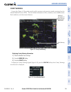
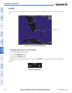
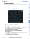
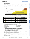
The terrain and obstacle databases used by TAWS are referenced to mean sea level (MSL). Using the GPS
position and GPS-MSL altitude, TAWS displays a 2-D picture of the surrounding terrain and obstacles relative
to the position and altitude of the aircraft. Furthermore, the GPS position and GPS-MSL altitude are used to
calculate and “predict” the aircraft’s flight path in relation to the surrounding terrain and obstacles. In this
manner, TAWS can provide advanced alerts of predicted dangerous terrain conditions.
Baro-corrected altitude (or indicated altitude) is derived by adjusting the altimeter setting for local atmospheric
conditions. The most accurate baro-corrected altitude can be achieved by frequently updating the altimeter
setting to the nearest reporting station along the flight path. However, because actual atmosphere conditions
seldom match the standard conditions defined by the International Standard Atmosphere (ISA) model (where
pressure, temperature, and lapse rates have fixed values), it is common for the baro-corrected altitude (as read
from the altimeter) to differ from the GPS-MSL altitude. This variation results in the aircraft’s true altitude
differing from the baro-corrected altitude.