


190-00595-01 Rev. B
Garmin G1000 Pilot’s Guide for the Beechcraft A36/G36
153
FLIGHT MANAGEMENT
SYSTEM
OVERVIEW
FLIGHT
INSTRUMENTS
EIS
AUDIO PANEL
& CNS
FLIGHT
MANAGEMENT
HAZARD
AVOIDANCE
AFCS
ADDITIONAL
FEATURES
APPENDICES INDEX
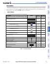
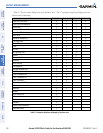
The following range items are configurable on the airways menu:
Airway Type Symbol Default
Range (nm)
Maximum
Range (nm)
Low Altitude Airway (LOW ALT AIRWAY)
200 500
High Altitude Airway (HI ALT AIRWAY)
300 500
Table 5-4 Airway Range Information
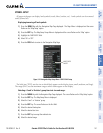
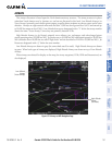
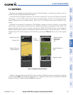
TRACK VECTOR
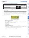
The Navigation Map can display a track vector that is useful in minimizing track angle error. The track vector
is a dashed light blue line segment with an arrowhead attached to the end, extended to a predicted location
along the current aircraft track. The track vector look-ahead time is selectable (30 sec, 60 sec (default), 2 min,
5 min, 10 min, 20 min) and determines the length of the track vector. The arrowhead is continuously pointing
to the predicted aircraft location.
Figure 5-24 Navigation Map -Track Vector
Track Vector
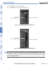
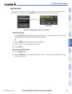
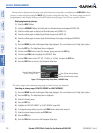
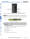
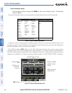
Displaying/removing the track vector:
1) Press the MENU Key with the Navigation Map Page displayed. The cursor flashes on the ‘Map Setup’ option.
2) Press the ENT Key. The Map Setup Menu is displayed.
3) Select the ‘Map’ group.
4) Press the ENT Key.
5) Highlight the ‘TRACK VECTOR’ field.
6) Select ‘On’ or ‘Off’. Press the ENT Key to accept the selected option. The flashing cursor highlights the look
ahead time field. Use the FMS Knob to select the desired time. Press the ENT Key.
7) Press the FMS Knob to return to the Navigation Map Page.