


Garmin G1000 Pilot’s Guide for the Beechcraft A36/G36
190-00595-01 Rev. B
298
HAZARD AVOIDANCE
SYSTEM
OVERVIEW
FLIGHT
INSTRUMENTS
EIS
AUDIO PANEL
& CNS
FLIGHT
MANAGEMENT
HAZARD
AVOIDANCE
AFCS
ADDITIONAL
FEATURES
APPENDICESINDEX
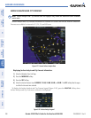
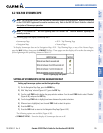
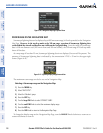
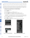
Figure 6-40 Navigation Map Page Options Menu
ZOOM RANGE ON THE NAVIGATION MAP
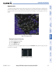
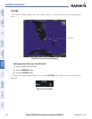
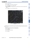
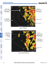
Stormscope lightning data can be displayed up to 800 nm zoom range (in North up mode) on the Navigation
Map Page.
However, in the track up mode at the 500 nm range, a portion of Stormscope lightning data
can be behind the aircraft and therefore not visible on the Navigation Map
. Since the range for Stormscope
data is 400 nm diameter total (200 nm in front and 200 nm behind), the 500 nm range in North up mode
shows all the data.
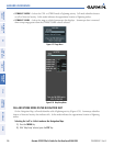
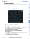
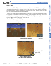
At a map range of less than 25 nm, Stormscope lightning data is not displayed, but can still be present. The
presence of Stormscope lightning data is indicated by the annunciation ‘LTNG < 25 nm’ in the upper right
corner (Figure 6-41).
Figure 6-41 Lightning Display Range Annunciation
The maximum zoom range can also be set on the Navigation Map.
Selecting a Stormscope range on the Navigation Map:
1) Press the MENU Key.
2) Select ‘MAP SETUP’.
3) Select the ‘Weather’ group.
4) Press the ENT Key.
5) Turn the
large FMS
Knob to select ‘STRMSCP SMBL’.
6) Turn the
small FMS
Knob to select the maximum display range.
7) Press the
ENT
Key.
8) Press the
FMS
Knob to return to the Navigation Map Page.
To change the display range on the Navigation Map Page, turn the RANGE Knob clockwise to zoom out or
counter-clockwise to zoom in.