


190-00595-01 Rev. B
Garmin G1000 Pilot’s Guide for the Beechcraft A36/G36
283
HAZARD AVOIDANCE
SYSTEM
OVERVIEW
FLIGHT
INSTRUMENTS
EIS
AUDIO PANEL
& CNS
FLIGHT
MANAGEMENT
HAZARD
AVOIDANCE
AFCS
ADDITIONAL
FEATURES
APPENDICES INDEX
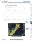
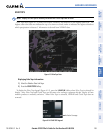
ECHO TOPS
NOTE: Display of Echo Tops is mutually exclusive with Cloud Tops and NEXRAD.
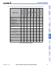
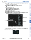
Echo Tops data (Figure 6-13) shows the location, elevation, and direction of the highest radar echo. The
highest radar echo does not indicate the top of a storm or clouds; rather it indicates the highest altitude at
which precipitation is detected. Information is derived from NEXRAD data.
Figure 6-13 Echo Tops Data
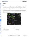
Displaying Echo Tops information:
1) Select the Weather Data Link Page.
2) Press the ECHO TOPS Softkey.
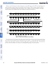
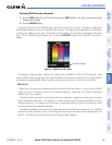
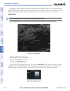
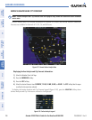
To display the Echo Tops legend (Figure 6-14), press the LEGEND Softkey when Echo Tops is selected for
display. Since Echo Tops and Cloud Tops use the same color scaling to represent altitude, display of these
weather products is mutually exclusive. When Echo Tops is activated, NEXRAD and Cloud Tops data are
removed.
Figure 6-14 ECHO TOPS Legend
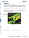
No Radar Coverage