


190-00595-01 Rev. B
Garmin G1000 Pilot’s Guide for the Beechcraft A36/G36
177
FLIGHT MANAGEMENT
SYSTEM
OVERVIEW
FLIGHT
INSTRUMENTS
EIS
AUDIO PANEL
& CNS
FLIGHT
MANAGEMENT
HAZARD
AVOIDANCE
AFCS
ADDITIONAL
FEATURES
APPENDICES INDEX
Map ranges for the airspace boundaries are selected from the Aviation Group in the Map Setup Menu: See Table
5-2 for the default and maximum ranges for each type of airspace and the symbol used to define the airspace
area.
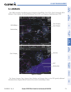
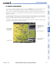
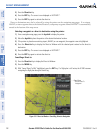
The Nearest Airspaces Page can be used to quickly find airspaces close to the flight path. In addition, a selected
frequency associated with the airspace can be loaded from the Nearest Airspaces Page. In addition to displaying
a map of airspace boundaries and surrounding area, the Nearest Airspaces Page displays airspace information in
four boxes labeled ‘AIRSPACE ALERTS’, ‘AIRSPACE, AGENCY’, VERTICAL LIMITS’, and ‘FREQUENCIES’.
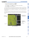
Figure 5-47 Nearest Airspaces Page
Airspace Alerts Info
- Name
- Proximity (Ahead, Inside,
Ahead < 2nm, Within 2nm)
- Time till Intercept (only if
Ahead or Ahead < 2nm
Airspace Vertical Limits
- Ceiling
- Floor
Airspace/Agency Info
- Airspace Type
- Controlling Agency
Softkeys
Airspace 1
Associated Frequencies
- Type
- Availability/Info
- Frequency
Airspace 2
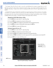
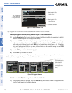
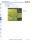
Airspace alerts and associated frequencies are shown in scrollable lists on the Nearest Airspaces Page. The
ALERTS and FREQ softkeys place the cursor in the respective list. The FREQ Softkey is enabled only if one or
more frequencies exist for a selected airspace.
Selecting and viewing an airspace alert with its associated information:
1) Select the Nearest Airspace Page.
2) Press the ALERTS Softkey; or press the FMS Knob; or press the MENU Key, highlight ‘Select Alerts Window’,
and press the ENT Key. The cursor is placed in the ‘AIRSPACE ALERTS’ Box.
3) Select the desired airspace.
4) Press the FMS Knob to remove the flashing cursor.