


Garmin G1000 Pilot’s Guide for the Beechcraft A36/G36
190-00595-01 Rev. B
288
HAZARD AVOIDANCE
SYSTEM
OVERVIEW
FLIGHT
INSTRUMENTS
EIS
AUDIO PANEL
& CNS
FLIGHT
MANAGEMENT
HAZARD
AVOIDANCE
AFCS
ADDITIONAL
FEATURES
APPENDICESINDEX
METARS AND TAFS
NOTE: Atmospheric pressure as reported for METARs is given in hectopascals (hPa), except for in the United
States, where it is reported in inches of mercury (in Hg). Temperatures are reported in Celsius.
NOTE: METAR information is only displayed within the installed aviation database service area.
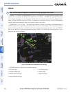
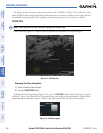
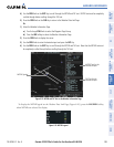
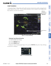
METAR (METeorological Aerodrome Report) is the standard format for pre-flight weather briefings.
METARs are updated hourly and are considered current. METARs typically contain information about the
temperature, dewpoint, wind, precipitation, cloud cover, cloud heights, visibility, and barometric pressure.
They can also contain information on precipitation amounts, lightning, and other critical data. METARs are
shown as colored flags at airports that provide them.
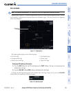
Figure 6-24 METAR Flags on the Weather Data Link Page
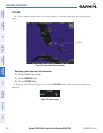
Instructions for Viewing
METAR and TAF Text
Selected Airport
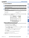
TAF (Terminal Aerodrome Report) is the standard format for 24-hour weather forecasts. TAFs may contain
some METAR data, but generally cover a smaller area. It typically forecasts significant weather changes,
temporary changes, probable changes, and expected changes in weather conditions.
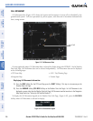
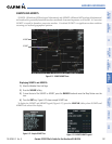
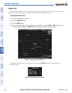
METAR and TAF text are displayed on the Weather Information Page. METAR data is displayed first in a
decoded fashion, then as raw text. TAF information is displayed only in its raw form.
Displaying METAR and TAF text:
1) On the Weather Data Link Page, press the METAR Softkey.
2) Press the RANGE Knob and pan to the desired airport.
3) Press the ENT Key. The Weather Information Page is shown with METAR and TAF text.