


190-00595-01 Rev. B
Garmin G1000 Pilot’s Guide for the Beechcraft A36/G36
141
FLIGHT MANAGEMENT
SYSTEM
OVERVIEW
FLIGHT
INSTRUMENTS
EIS
AUDIO PANEL
& CNS
FLIGHT
MANAGEMENT
HAZARD
AVOIDANCE
AFCS
ADDITIONAL
FEATURES
APPENDICES INDEX
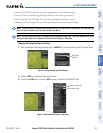
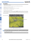
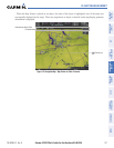
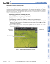
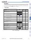
MEASURING BEARING AND DISTANCE
Distance and bearing from the aircraft’s present position to any point on the viewable navigation map may be
calculated using the ‘Measure Bearing and Distance’ selection from Navigation Map page menu. The bearing
and distance tool displays a dashed Measurement Line and a Measure Pointer to aid in graphically identifying
points with which to measure. Lat/Long, distance and elevation data for the Measure Pointer is provided in a
window at the top of the navigation map.
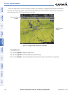
Measuring bearing and distance between any two points:
1) Press the MENU Key (with the Navigation Map Page displayed).
2) Highlight the ‘Measure Bearing/Distance’ field.
3) Press the ENT Key. A Measure Pointer is displayed on the map at the aircraft’s present position.
4) Move the Joystick to place the reference pointer at the desired location. The bearing and distance are displayed
at the top of the map. Elevation at the current pointer position is also displayed. Pressing the ENT Key changes
the starting point for measuring.
5) To exit the Measure Bearing/Distance option, press the Joystick; or select ‘Stop Measuring’ from the Page
Menu and press the ENT Key.
Figure 5-13 Navigation Map - Measuring Bearing and Distance
Pointer Lat/Long
Measurement
Information
Measurement Line