


Garmin G1000 Pilot’s Guide for the Beechcraft A36/G36
190-00595-01 Rev. B378
ADDITIONAL FEATURES
SYSTEM
OVERVIEW
FLIGHT
INSTRUMENTS
EIS
AUDIO PANEL
& CNS
FLIGHT
MANAGEMENT
HAZARD
AVOIDANCE
AFCS
ADDITIONAL
FEATURES
APPENDICESINDEX
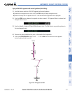
Any map page that displays the navigation view can also show the SafeTaxi airport layout within the maximum
configured range. The following is a list of pages where the SafeTaxi feature can be seen:
• Navigation Map Page
• Inset Map (PFD)
• Weather Datalink Page
• Airport Information Page
• Intersection Information Page
• NDB Information Page
• VOR Information Page
• User Waypoint Information Page
• Trip Planning Page
• Nearest Pages
• Active and Stored Flight Plan Pages
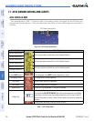
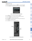
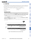
During ground operations the aircraft’s position is displayed in reference to taxiways, runways, and airport
features. In the example shown, the aircraft is on taxiway Bravo inside the High Alert Intersection boundary
on KSFO airport. Airport Hot Spots are outlined in magenta. When panning over the airport, features such as
runway holding lines and taxiways are shown at the cursor.
Figure 8-1 SafeTaxi Depiction on the Navigation Map Page
DCLTR
Softkey
Removes Taxiway
Markings
Airport
Features
Aircraft
Position
Taxiway
Identification
Airport Hot
Spot Outline
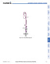
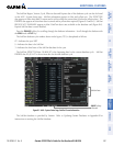
The DCLTR Softkey (declutter) label advances to DCLTR-1, DCLTR -2, and DCLTR-3 each time the softkey is
pressed for easy recognition of decluttering level. Pressing the DCLTR Softkey removes the taxiway markings
and airport feature labels. Pressing the DCLTR-1 Softkey removes VOR and station ID, the VOR symbol, and
intersection names if within the airport plan view. Pressing the DCLTR-2 Softkey removes the airport diagram
and runway layout, unless the airport in view is part of an active route structure. Pressing the DCLTR-3 Softkey
cycles back to the original map detail. Refer to Map Declutter Levels in the Flight Management Section.