


190-00595-01 Rev. B
Garmin G1000 Pilot’s Guide for the Beechcraft A36/G36
18
SYSTEM OVERVIEW
SYSTEM
OVERVIEW
FLIGHT
INSTRUMENTS
EIS
AUDIO PANEL
& CNS
FLIGHT
MANAGEMENT
HAZARD
AVOIDANCE
AFCS
ADDITIONAL
FEATURES
APPENDICESINDEX
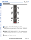
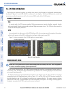
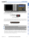
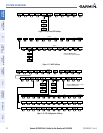
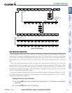
SOFTKEY FUNCTION
The softkeys are located along the bottoms of the displays. The softkeys shown depend on the softkey level
or page being displayed. The bezel keys below the softkeys can be used to select the appropriate softkey. When
a softkey is selected, its color changes to black text on gray background and remains this way until it is turned
off, at which time it reverts to white text on black background.
Softkey Names (displayed)
Figure 1-15 Softkeys (Second-Level PFD Configuration)
Bezel-Mounted Softkeys (press)
Softkey On
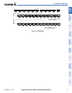
PFD SOFTKEYS
The
CDI
,
IDENT
,
TMR/REF
,
NRST,
and
ALERTS
Softkeys undergo a momentary change to black text
on gray background and automatically switch back to white text on black background when selected. If
messages remain after acknowledgement, the ALERTS
Softkey is black on white.
The PFD softkeys provide control over flight management functions, including GPS, NAV, terrain, traffic,
and lightning. Each softkey sublevel has a
BACK Softkey which can be pressed to return to the previous
level. The ALERTS Softkey is visible in all softkey levels. For the top level softkeys and the transponder
(XPDR) levels, the IDENT Softkey remains visible.
INSET
Displays Inset Map in PFD lower left corner
OFF
Removes Inset Map
DCLTR (3)
Selects desired amount of map detail; cycles through declutter levels:
DCLTR (No Declutter): All map features visible
DCLTR-1: Declutters land data
DCLTR-2: Declutters land and SUA data
DCLTR-3: Removes everything except for the active flight plan
TRAFFIC
Displays traffic information on Inset Map
TOPO
Displays topographical data (e.g., coastlines, terrain, rivers, lakes) and elevation scale
on Inset Map
TERRAIN
Displays terrain information on Inset Map
STRMSCP
Displays Stormscope information on Inset Map (optional)
NEXRAD
Displays NEXRAD weather and coverage on Inset Map (optional)
XM LTNG
Displays XM lightning information on Inset Map (optional)
PFD
Displays second-level softkeys for additional PFD configurations
DFLTS
Resets PFD to default settings, including changing units to standard
WIND
Displays softkeys to select wind data parameters
OPTN 1
Longitudinal and lateral components
OPTN 2
Total direction and speed
OPTN 3
Total direction with head and crosswind speed components
OFF
Information not displayed