


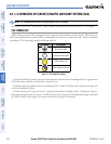

190-00595-01 Rev. B
Garmin G1000 Pilot’s Guide for the Beechcraft A36/G36
315
HAZARD AVOIDANCE
SYSTEM
OVERVIEW
FLIGHT
INSTRUMENTS
EIS
AUDIO PANEL
& CNS
FLIGHT
MANAGEMENT
HAZARD
AVOIDANCE
AFCS
ADDITIONAL
FEATURES
APPENDICES INDEX
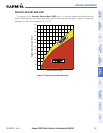
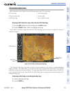
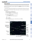
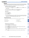
TRAFFIC MAP PAGE
The Traffic Map Page is specialized to show surrounding TIS traffic data in relation to the aircraft’s current
position and altitude, without clutter from the basemap. Aircraft orientation on this map is always heading up
unless there is no valid heading. Map range is adjustable with the RANGE Knob from 2 to 12 nm, as indicated
by the map range rings.
The traffic mode is annunciated in the upper left corner of the Traffic Map Page. When the aircraft is on the
ground, TIS automatically enters Standby Mode. Once the aircraft is airborne, TIS switches from Standby to
Operating Mode and the G1000 begins to display traffic information. Refer to the System Status discussion for
more information.
Displaying traffic on the Traffic Map Page:
1) Turn the large
FMS
Knob to select the Map Page Group.
2) Turn the small
FMS
Knob
to select the Traffic Map Page.
3) Confirm TIS is in Operating Mode:
Press the
OPERATE
Softkey to begin displaying traffic.
Or:
a) Press the
MENU
Key.
b) Select ‘Operate Mode’ (shown if TIS is in Standby Mode) and press the ENT Key.
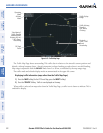
Figure 6-60 Traffic Map Page
Non-Threat
Traffic
Proximity
Advisory
1700’
Above,
Descending
“Non-Bearing” Traffic
(System Unable to
Determine Bearing)
Distance is 8.0 nm,
1100’ Above,
Descending
Non-Threat
Traffic
Traffic Advisory
400’ Below,
Climbing
Traffic Status
Banner
Traffic Mode Annunciation
“TIS Not Available”
Voice Alert Status
Range
Marking
Rings
Select
to Mute
“TIS Not
Available”
Voice Alert