


Garmin G1000 Pilot’s Guide for the Beechcraft A36/G36
190-00595-01 Rev. B
312
HAZARD AVOIDANCE
SYSTEM
OVERVIEW
FLIGHT
INSTRUMENTS
EIS
AUDIO PANEL
& CNS
FLIGHT
MANAGEMENT
HAZARD
AVOIDANCE
AFCS
ADDITIONAL
FEATURES
APPENDICESINDEX
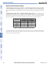
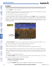
6.4 TRAFFIC INFORMATION SERVICE (TIS)
WARNING
: The Traffic Information Service (TIS) is intended for advisory use only. TIS is intended to help the
pilot locate traffic visually. It is the responsibility of the pilot to see and maneuver to avoid traffic.
NOTE: TIS is available only when the aircraft is within the service volume of a TIS-capable terminal radar
site. Aircraft without an operating transponder are invisible to both Traffic Advisory Systems (TAS) and TIS.
Aircraft without altitude reporting capability are shown without altitude separation data or climb descent
indication.
NOTE: TIS is disabled if a Traffic Advisory System (TAS) is installed.
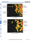
Traffic Information Service (TIS) is designed to help in detection and avoidance of other aircraft. TIS uses the
Mode S transponder for the traffic data link. TIS receives traffic information from ground stations, and is updated
every 5 seconds. The G1000 displays up to eight traffic targets within a 7.5-nm radius, from 3000 feet below to
3500 feet above the requesting aircraft. Traffic is displayed according to TCAS symbology using four different
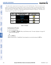
symbols (Table 6-9).
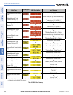
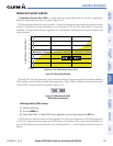
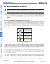
TIS Symbol Description
Non-Threat Traffic
Proximity Advisory (PA)
Traffic Advisory (TA)
Traffic Advisory Off Scale
Table 6-9 TIS Traffic Symbols
Proximity Advisories (PAs) are defined as traffic within the 5.0-nm range, within ±1200 feet of altitude separation.
They are not Traffic Advisories (TA), which alert the crew to intruding aircraft. When traffic meets the advisory
criteria for the TA, a solid yellow circle symbol is generated. A TA which is detected but is outside the range of
the map on which traffic is displayed are indicated with a message in the lower left corner of the map.
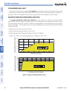
TIS also provides a vector line showing the direction in which the traffic is moving, to the nearest 45°. Traffic
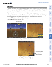
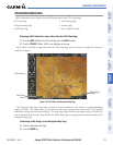
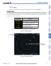
information for which TIS is unable to determine the bearing (non-bearing traffic) is displayed in the center of
the Traffic Map Page (Figure 6-60) or in a banner at the lower left corner of maps other than the Traffic Map Page
on which traffic can be displayed.
The altitude difference between the requesting aircraft and other intruder aircraft is displayed above/below the
traffic symbol in hundreds of feet. If the other aircraft is above the requesting aircraft, the altitude separation
appears above the traffic symbol; if below, the altitude separation appears below. Altitude trend is displayed as
an up/down arrow (for speeds greater than 500 fpm in either direction) to the right of the target symbol. Traffic
symbols for aircraft without altitude reporting capability appear without altitude separation or climb/descent
information.