


190-00595-01 Rev. B
Garmin G1000 Pilot’s Guide for the Beechcraft A36/G36
377
ADDITIONAL FEATURES
SYSTEM
OVERVIEW
FLIGHT
INSTRUMENTS
EIS
AUDIO PANEL
& CNS
FLIGHT
MANAGEMENT
HAZARD
AVOIDANCE
AFCS
ADDITIONAL
FEATURES
APPENDICES INDEX
SECTION 8 ADDITIONAL FEATURES
NOTE: The availability of SafeTaxi, ChartView, or FliteCharts in electronic form may not preclude the
requirement to carry paper charts aboard the aircraft. See AC 120-76A for more information.
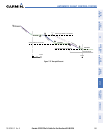
Additional features of the G1000 include the following:
• SafeTaxi™ diagrams
• ChartView and FliteCharts™ electronic charts
• XM Radio entertainment
• Scheduler
SafeTaxi diagrams provide detailed taxiway, runway, and ramp information at more than 700 airports in the
United States. By decreasing range on an airport that has a SafeTaxi diagram available, a close up view of the
airport layout can be seen.
The optional ChartView and FliteCharts provide on-board electronic terminal procedures charts. Electronic
charts offer the convenience of rapid access to essential information. Either ChartView or FliteCharts may be
configured in the system, but not both.
The optional XM Radio entertainment audio feature of the GDL 69A Data Link Receiver handles more than 170
channels of music, news, and sports. XM Radio offers more entertainment choices and longer range coverage
than commercial broadcast stations.
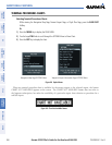
The Scheduler feature can be used to enter and display short term or long term reminder messages such as
Switch fuel tanks, Change oil, or Altimeter-Transponder Check in the Alerts Window on the PFD.
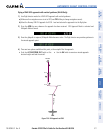
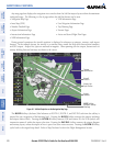
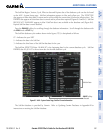
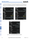
8.1 SAFETAXI
SafeTaxi is an enhanced feature that gives greater map detail when viewing airports at close range. The maximum
map ranges for enhanced detail are pilot configurable. When viewing at ranges close enough to show the airport
detail, the map reveals taxiways with identifying letters/numbers, airport Hot Spots, and airport landmarks
including ramps, buildings, control towers, and other prominent features. Resolution is greater at lower map
ranges. When the aircraft location is within the screen boundary, including within SafeTaxi ranges, an airplane
symbol is shown on any of the navigation map views for enhanced position awareness.
Designated Hot Spots are recognized at airports with many intersecting taxiways and runways, and/or complex
ramp areas. Airport Hot Spots are outlined to caution pilots of areas on an airport surface where positional
awareness confusion or runway incursions happen most often. Hot Spots are defined with a magenta circle or
outline around the region of possible confusion.