


190-00595-01 Rev. B
Garmin G1000 Pilot’s Guide for the Beechcraft A36/G36
285
HAZARD AVOIDANCE
SYSTEM
OVERVIEW
FLIGHT
INSTRUMENTS
EIS
AUDIO PANEL
& CNS
FLIGHT
MANAGEMENT
HAZARD
AVOIDANCE
AFCS
ADDITIONAL
FEATURES
APPENDICES INDEX
XM LIGHTNING
NOTE: XM Lightning and optional L-3 STORMSCOPE
®
WX-500 Lightning are mutually exclusive
.
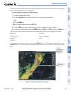
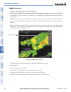
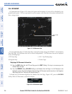
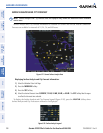
Lightning data (Figure 6-17) shows the approximate location of cloud-to-ground lightning strikes. A strike
icon represents a strike that has occurred within a two-kilometer region. The exact location of the lightning
strike is not displayed.
Figure 6-17 Lightning Data
Lightning
Strikes
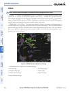
XM Lightning data displays on the following maps:
• PFD Inset Map
• Navigation Map Page
• Weather Data Link Page
• Trip Planning Page
• Nearest Pages
• Flight Plan Pages
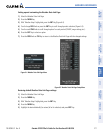
Displaying XM Lightning information:
1) Press the MAP Softkey (for the PFD Inset Map, press the INSET Softkey). This step is not necessary on the
Weather Data Link Page.
2) Press the XM LTNG Softkey (LTNG Softkey on the Weather Data Link Page).
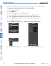
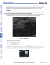
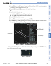
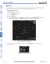
To display the XM Lightning legend on the Weather Data Link Page (Figure 6-18), press the LEGEND
Softkey when XM Lightning is selected for display.
Figure 6-18 Lightning Legend