


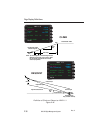
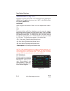
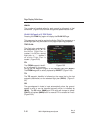
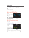

NM/LB:
The number of nautical miles for each pound (or kilogram) of fuel
consumed. (Figure 2-50)Fuel flow and ground speed must be valid.
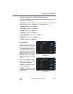
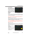
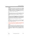
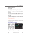
PLAN 2/8 (Page 2 of 8) TRIP PLAN
Pressing the PLAN Key again will display the PLAN 2/8 Page.
This page may be used to monitor the Active Flight Plan progress or a
stored flight plan may be loaded on this page for planning purposes.
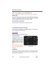
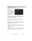
TRIP PLAN:
The flight plan selected will
be designated by an "A" for
the Active Flight Plan, a
number (1 to 56) for a stored
flight plan, or - - - dashes if
no active Flight Plan is
loaded. (Figure 2-52)
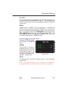
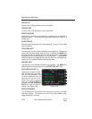
FR:
The FROM waypoint identifi-
er is followed on the same
line by the first waypoint (origin) on the selected flight plan (KDAL).
The FROM waypoint is usually replaced by DIRECT. (Figure 2-52)
TO:
The TO waypoint identifier is followed on the same line by the last
waypoint (destination) on the selected flight plan (RW34). (Figure 2-
52)
GS:
The groundspeed in knots is input automatically when the ground-
speed is valid or can be inserted manually which is indicated by
(MAN). The GS value, (MAN) and ETA value will change to yellow.
(CALC) will replace (MAN) field if a manual ETA is entered on line 9.
(Figure 2-52)
Page Display Definitions
2-44
GNS-XL Flight Management System
Rev. 0
Oct/96
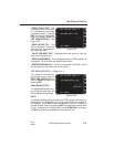
TRIP PLAN A
DIRECT KDAL
TO ELD RW34
GS (MAN) 254
DIS/DTK 21.0/T073
ETE 00:16.5
FPL 1346/05+18
ETA @ LIT 16:18
RAIM @ LIT AVAIL
PLAN 2/8
<
<
<
<
Figure 2-52