


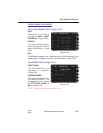
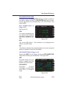
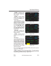
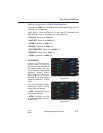
• CLIMB: Indicates climb
required to cruise altitude or to
next altitude restriction.
(Figure 2-38)
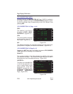
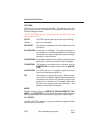
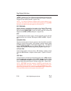
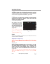
• CRUISE: Indicates holding
altitude while enroute to Top
of Descent (#TOD) point.
(Figure 2-39)
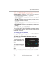
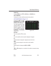
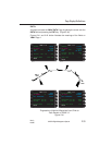
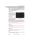
• PATH DESCENT: Indicates
descent via programmed
Flight Path Angle. Vertical
Deviation will be enabled on
the Vertical Deviation needle
and the VERT DEV field is
active. The VERT DEV field
will not be displayed if there is
no vertical path programmed.
(Figure 2-40)
• DESCENT: Indicates non-
path or Air Mass descent to
altitude restriction.
• LEVEL: Indicates aircraft
should fly level to next con-
straint.
TO Waypoint:
Vertical TO waypoint with con-
straint altitude and applicable
waypoint offset. Letters pre-
ceding or following the altitude
constraint have the following
meaning: FL=Flight Level, A=
At or Above, B=At or Below,
G=Glide Path, and a blank
space=At constraint.
One of the following system generated VNAV profile points may also
appear as the TO waypoint:
• #TOC: Indicates the Top of Climb target altitude. This point becomes
the Vertical TO Waypoint once the aircraft has passed the final climb
constraint waypoint and is climbing. (Figure 2-40)
Page Display Definitions
2-33
GNS-XL Flight Management System
Rev. 0
Oct/96
CLIMB 5566
TO #TOC FL350
RANGE (NM) 300.4
ETE 01:13.5
ACTUAL FPM UP 400
CLIMB GRAD 97 /NM
DATA
VNAV 1/3
<
<
<
<
<
<
Figure 2-38
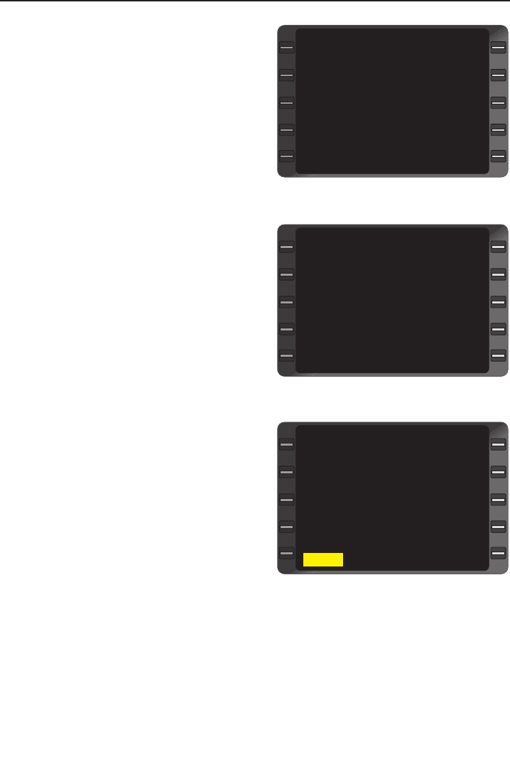
CRUISE FL350
TO #TOD FL350
RANGE (NM) 1214.4
ETE 08:06.8
@ #TOD FPM DN 800
ACTUAL FPM UP 0
VERT DEV -----
DATA
VNAV 1/3
<
<
<
<
<
<
Figure 2-39
PATH DESCENT FL345
TO ELD -5 FL250G
EST CROSSING FL250
REQUIRED FPM DN 600
ACTUAL FPM DN 600
VERT DEV HIGH 87
DATA?
VNAV 1/3
<
<
<
<
<
Figure 2-40