


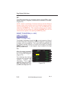

Page Display Definitions
2-72
GNS-XL Flight Management System
Rev. 0
Oct/96
#0 will be defined as the point at which the aircraft completes the turn
and intercepts the direct course to the fix. #0 will momentarily be dis-
played on an EFIS map. #0 can only be defined by the system.
#1 The position at the point where the POSITION FIX Page was last
accessed via the HOLD Key. #1 can only be defined by the system.
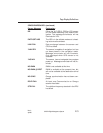
Power Off Waypoint
The Power Off Waypoint is a set of coordinates retrieved as the last
known position when power is lost enroute. This page should be
accessed by inserting #OFF in the IDENT field on the POSITION FIX
Page after power has been restored and Initialization Enroute has
been performed.
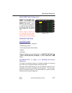
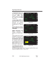
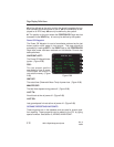
WAYPOINT #OFF:
The Power Off Waypoint des-
ignator. (Figure 2-88)
POS:
The last present position
coordinates at loss of power.
Coordinates are stored in
non-volatile memory. (Figure
2-88)
GMT OFF:
The actual time (Greenwich Mean Time) of power loss. (Figure 2-88)
MINUTES OFF:
The total time elapsed during power off. (Figure 2-88)
LAST TK:
Aircraft track at time of power off. (Figure 2-88)
LAST GS:
Last groundspeed in knots at time of power off. (Figure 2-88)
OCEANIC REPORTING WAYPOINTS
These waypoints are in the database and are used for oceanic posi-
tion reporting. These waypoints can be added to the FPL by typing
special numbers. See Section 3, ADDING A WAYPOINT.
WAYPOINT *OFF
POS N 42 08.00
W074 49.90
GMT OFF 00:13
MINUTES OFF 01.1
LAST TK 281
LAST GS 251
SPECIAL WPT
Figure 2-88