


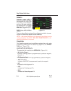

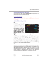
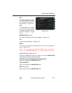
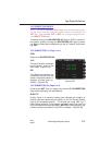

DIS:
The distance in nautical miles
and tenths from the aircraft
present position to the TO
waypoint. During Waypoint
Alert, the distance in whole
nautical miles to the NX way-
point on the Active Flight
Plan is displayed in parenthe-
ses. (Figure 2-18)
ETE:
The estimated time enroute in hours, minutes and tenths, from the air-
craft present position to the TO waypoint based on current ground-
speed. (Figure 2-18)
DTK:
The desired track is the Great Circle course in whole degrees
between the FROM and TO waypoints. When in the PSEUDO VOR-
TAC mode, the DTK is entered by the operator. During the Waypoint
Alert, desired track to the next (NX) waypoint on the Active Flight Plan
is displayed in parentheses. (Figure 2-18)
NOTE: The DTK field will be dashes if the FROM waypoint or pre-
sent position are north of N 70° or south of S 60° Latitude, unless a
manual MAG VAR is entered or a discrete MAG/True switch is moved
to the True position.
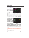
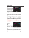
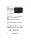
GS:
The current groundspeed.
(Figure 2-19)
WIND:
The current wind direction
referenced to True North and
speed in knots. (Figure 2-
19)
XFILL:
If the aircraft is configured for dual systems, the XFILL prompt will
appear on line 10 indicating the systems contain dissimilar data.
Page Display Definitions
2-14
GNS-XL Flight Management System
Rev. 0
Oct/96
FR 19DFW 20:28
TO ELD 20:30
NX MEI 21:49
DIS (42) 1.6
ETE 00:00.6
DTK (90) 074
GS 156
WIND 284/ 7
-AUTO-
NAVIGATION 1/4
<
<
<
<
<
Figure 2-18
FR KHART 20:02
TO 19DFW -10 15000A
DIS 47.3
ETE 00:19.4
DTK 079
GS 146
WIND 160/ 14
XFILL? -AUTO-
NAVIGATION 1/4
<
<
<
<
<
Figure 2-19