


Garmin G1000 Pilot’s Guide for the Diamond DA40/40F
190-00592-06 Rev A446
ADDITIONAL FEATURES
SYSTEM
OVERVIEW
FLIGHT
INSTRUMENTS
EIS
AUDIO PANEL
& CNS
FLIGHT
MANAGEMENT
HAZARD
AVOIDANCE
AFCS
ADDITIONAL
FEATURES
APPENDICESINDEX
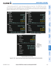
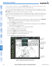
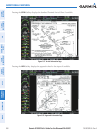
When a chart is not available by pressing the SHW CHRT Softkey or selecting a Page Menu Option, charts
may be obtained for other airports from the WPT Pages or Flight Plan Pages.
If a chart is available for the destination airport, or the airport selected in the active flight plan, the chart
appears on the screen. When no flight plan is active, or when not flying to a direct-to destination, pressing the
SHW CHRT Softkey displays the chart for the nearest airport, if available.
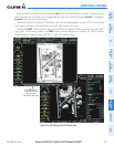
The chart shown is one associated with the WPT – Airport Information page. Usually this is the airport runway
diagram. Where no runway diagram exists, but Take Off Minimums or Alternate Minimums are available, that
page appears. If Airport Information pages are unavailable, the Approach Chart for the airport is shown.
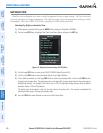
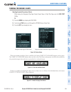
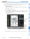
Selecting a chart:
1) While viewing the Navigation Map Page, Flight Plan Page, or Nearest Airports Page, press the SHW CHRT
Softkey. The airport diagram or approach chart is displayed on the Airport Information Page.
2) Press the
FMS
Knob to activate the cursor.
3) Turn the large FMS Knob to select either the Airport Identifier Box or the Approach Box. (Press the APR Softkey
if the Approach Box is not currently shown).
4) Turn the small and large FMS Knob to enter the desired airport identifier.
5) Press the ENT Key to complete the airport selection.
6) Turn the large FMS Knob to select the Approach Box.
7) Turn the small
FMS
Knob to show the approach chart selection choices.
8) Turn either
FMS
Knob to scroll through the available charts.
9) Press the ENT Key to complete the chart selection.
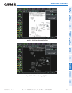
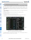
Select Desired
Approach Chart
from Menu
Pan Chart
With the
Joystick
Chart Not
To Scale
Aircraft Not
Shown Icon
Figure 8-52 Approach Information Page, Chart Selection