


190-00592-06 Rev. A
Garmin G1000 Pilot’s Guide for the Diamond DA40/40F
291
HAZARD AVOIDANCE
SYSTEM
OVERVIEW
FLIGHT
INSTRUMENTS
EIS
AUDIO PANEL
& CNS
FLIGHT
MANAGEMENT
HAZARD
AVOIDANCE
AFCS
ADDITIONAL
FEATURES
APPENDICES INDEX
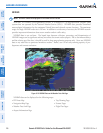
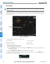
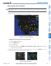
The display of radar coverage is always active when either NEXRAD or ECHO TOPS is selected. Areas
where NEXRAD radar coverage and Echo Tops information is not currently available or is not being collected
are indicated in grayish-purple. Radar capability exists in these areas, but it is not active or is off-line.
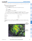
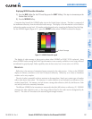
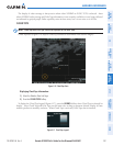
CLOUD TOPS
NOTE: Cloud Tops and Echo Tops cannot be displayed at the same time.
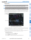
Cloud Tops data (Figure 6-16) depicts cloud top altitudes as determined from satellite imagery.
Figure 6-16 Cloud Tops Data
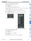
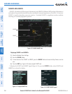
Displaying Cloud Tops information:
1) Select the Weather Data Link Page.
2) Press the CLOUD TOPS Softkey.
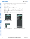
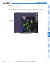
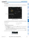
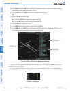
To display the Cloud Tops legend (Figure 6-17), press the
LEGEND
Softkey when Cloud Tops is selected for
display. Since Cloud Tops and Echo Tops use the same color scaling to represent altitude, display of these
weather products is mutually exclusive. When Cloud Tops is activated, Echo Tops data is removed.
Figure 6-17 Cloud Tops Legend