


190-00592-06 Rev. A
Garmin G1000 Pilot’s Guide for the Diamond DA40/40F
349
HAZARD AVOIDANCE
SYSTEM
OVERVIEW
FLIGHT
INSTRUMENTS
EIS
AUDIO PANEL
& CNS
FLIGHT
MANAGEMENT
HAZARD
AVOIDANCE
AFCS
ADDITIONAL
FEATURES
APPENDICES INDEX
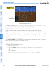
DISPLAYING TRAFFIC DATA
Traffic information is displayed on the following maps:
•PFDInsetMap
•NavigationMapPage
•TrafcMapPage
•TripPlanningPage
•NearestPages
•ActiveFlightPlanPage
Displaying traffic on the Traffic Map Page:
1) Turn the large
FMS
Knob to select the Map Page Group.
2) Turn the small
FMS
Knob
to select the Traffic Map Page.
3) Turn the RANGE Knob clockwise to display a larger area or counter-clockwise to display a smaller area.
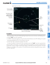
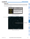
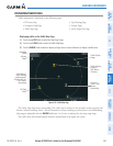
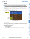
Figure 6-90 Traffic Map Page
Operating
Mode
Altitude
Mode
Traffic Advisory,
Aircraft is
400’ Below,
Climbing
Off Scale
Traffic
“Non-Bearing”
Traffic (Bearing
Undetermined),
Distance 8.0 nm,
1100’ Above,
Descending
Proximity
Traffic, 1000’
Above,
Descending
Traffic Display
Range
The Traffic Map Page shows surrounding TAS traffic data in relation to the aircraft’s current position and
altitude, without basemap clutter. Aircraft orientation is always heading up unless there is no valid heading.
Map range is adjustable with the RANGE Knob from 2 to 24 nm, as indicated by the map range rings.
The traffic mode and altitude display mode are annunciated in the upper left corner.