


190-00592-06 Rev. A
Garmin G1000 Pilot’s Guide for the Diamond DA40/40F
351
HAZARD AVOIDANCE
SYSTEM
OVERVIEW
FLIGHT
INSTRUMENTS
EIS
AUDIO PANEL
& CNS
FLIGHT
MANAGEMENT
HAZARD
AVOIDANCE
AFCS
ADDITIONAL
FEATURES
APPENDICES INDEX
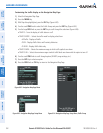
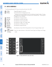
ALTITUDE DISPLAY
Changing the altitude display mode:
1) On the Traffic Page, press the
ALT MODE
Softkey.
2) Press one of the following Softkeys:
• BELOW
• NORMAL
• ABOVE
• UNREST (unrestricted)
3) To return to the Traffic Page, press the BACK Softkey.
Or:
1) Press the MENU Key.
2) Turn the small
FMS
Knob
to select one of the following:
• BELOW
• NORMAL
• ABOVE
• UNREST (unrestricted)
3) Press the ENT Softkey.
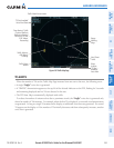
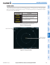
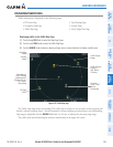
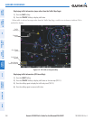
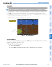
TRAFFIC MAP PAGE DISPLAY RANGE
The display range on the Traffic Map Page can be changed at any time. Map range is adjustable with the
RANGE Knob from 2 to 24 nm, as indicated by the map range rings.
Changing the display range on the Traffic Page:
1) Turn the RANGE Knob.
2) The following range options are available:
• 2 nm
• 2 and 6 nm
• 6 and 12 nm
• 12 and 24 nm
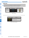
The Navigation Map Page Setup Menu also controls the display of traffic. The setup menu controls the map
range settings. Traffic data symbols and labels can be decluttered from the display. If a map range larger than
the map range setting is selected, the data is removed from the map. Maps besides the Traffic Map Page use
settings based on those selected for the Navigation Map Page.